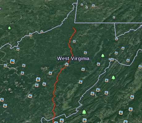
I encountered a remarkable resource, Proposed Route Using Google Earth and Geographic Information Systems (GIS) that details the route to be taken by the Mountain Valley Pipeline. (It’s hard to get in the way if you don’t know the route.)
But it requires use of Google Earth, an application I have only used on Windows. Time to change that!
Download Google Earth Pro for PC, Mac, or Linux then run:
sudo dpkg -i google-earth-stable_current_amd64.deb
in the same directory as the downloaded file.
It’s working!
Now back to the nifty resource I was talking about:
Dr. Stockton Maxwell, Assistant Professor of Geospatial Science at Radford University contacted EQT to request a Geographic Information Systems (GIS) request for the proposed pipeline route. A GIS is, in layman’s terms, a computer system that allows geographical data to be captured, stored, analyzed, and presented. Many counties and municipalities now use GIS to map all parcels and provide pertinent information on each parcel. Not surprising to those of us familiar with the EQT/NextEra Alliance, Mountain Valley Pipeline. LLC, they did not respond to Dr. Maxwell’s request. However, the company did have to share this information with the Virginia Department of Conservation and Recreation (DCR) as they are one of the stakeholders that must be notified during the pre-filing process. Dr. Maxwell contacted DCR and they shared the GIS information with him.
To make it easier for us to interpret the GIS information, Dr. Maxwell was kind enough to create a Google Earth file of the entire route (from Wetzel County, WV to Pittsylvania County, VA. He then created a buffer of 150 feet on each side of the route as this is the planned right-of-way during the construction phase of the project. To view this file, you will first need to download and install Google Earth — you can download it for free at: http://www.google.com/earth/download/ge/agree.html. Once you have downloaded Google Earth and installed it (or if you already have Google Earth installed), you will need to download the following file: http://preservethenrv.com/docs/MVP_Route.kmz. The file will download onto your computer. You can then Open the file (you will see the file name show at the bottom of your screen; click on the arrow to the right and select open) and it should open in Google Earth.
We are so lucky to have someone with Dr. Maxwell’s talents on our side — this resource will help landowners and citizens investigate the route better than the company’s maps.
A portion of the default view:
I’m going to be looking for places where accidental traffic congestion will delay construction. Critical sites that need re-routing will require boots on the ground to find and document those places. Got boots?
