Another Word For It Patrick Durusau on Topic Maps and Semantic Diversity

June 5, 2018

Installing Google Earth – Ubuntu 16.04 (Tooling to help “Preserve The New River Valley”)

Filed under: Environment,Google Earth,Google Maps,Government — Patrick Durusau @ 7:20 pm

I encountered a remarkable resource, Proposed Route Using Google Earth and Geographic Information Systems (GIS) that details the route to be taken by the Mountain Valley Pipeline. (It’s hard to get in the way if you don’t know the route.)

But it requires use of Google Earth, an application I have only used on Windows. Time to change that!

Download Google Earth Pro for PC, Mac, or Linux then run:

sudo dpkg -i google-earth-stable_current_amd64.deb

in the same directory as the downloaded file.

It’s working!

Now back to the nifty resource I was talking about:

Dr. Stockton Maxwell, Assistant Professor of Geospatial Science at Radford University contacted EQT to request a Geographic Information Systems (GIS) request for the proposed pipeline route. A GIS is, in layman’s terms, a computer system that allows geographical data to be captured, stored, analyzed, and presented. Many counties and municipalities now use GIS to map all parcels and provide pertinent information on each parcel. Not surprising to those of us familiar with the EQT/NextEra Alliance, Mountain Valley Pipeline. LLC, they did not respond to Dr. Maxwell’s request. However, the company did have to share this information with the Virginia Department of Conservation and Recreation (DCR) as they are one of the stakeholders that must be notified during the pre-filing process. Dr. Maxwell contacted DCR and they shared the GIS information with him.

To make it easier for us to interpret the GIS information, Dr. Maxwell was kind enough to create a Google Earth file of the entire route (from Wetzel County, WV to Pittsylvania County, VA. He then created a buffer of 150 feet on each side of the route as this is the planned right-of-way during the construction phase of the project. To view this file, you will first need to download and install Google Earth — you can download it for free at: http://www.google.com/earth/download/ge/agree.html. Once you have downloaded Google Earth and installed it (or if you already have Google Earth installed), you will need to download the following file: http://preservethenrv.com/docs/MVP_Route.kmz. The file will download onto your computer. You can then Open the file (you will see the file name show at the bottom of your screen; click on the arrow to the right and select open) and it should open in Google Earth.

We are so lucky to have someone with Dr. Maxwell’s talents on our side — this resource will help landowners and citizens investigate the route better than the company’s maps.

A portion of the default view:

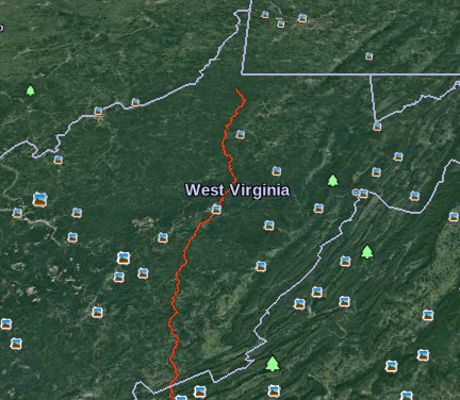
I’m going to be looking for places where accidental traffic congestion will delay construction. Critical sites that need re-routing will require boots on the ground to find and document those places. Got boots?

December 30, 2016

KML Documentation Introduction

Filed under: Google Earth,Google Maps,KML,Protests — Patrick Durusau @ 8:01 pm

KML Documentation Introduction

From the webpage:

If you’re new to KML, begin by browsing the KML Tutorial, which presents short samples of KML code that you can view in Google Earth.

The KML Reference provides detailed syntax for all KML elements, with explanations and diagrams of how to specify them.

The Developer’s Guide contains in-depth conceptual material and examples.

Creating and Sharing KML Files

You can create KML files with the Google Earth user interface, or you can use an XML or simple text editor to enter “raw” KML from scratch. KML files and their related images (if any) can be compressed using the ZIP format into KMZ archives. To share your KML and KMZ files, you can e-mail them, host them locally for sharing within a private internet, or host them publicly on a web server. Just as web browsers display HTML files, Earth browsers such as Google Earth display KML files. Once you’ve properly configured your server and shared the URL (address) of your KML files, anyone who’s installed Google Earth can view the KML files hosted on your public web server.

Many applications display KML, including Google Earth, NASA WorldWind, ESRI ArcGIS Explorer, Adobe PhotoShop, AutoCAD, and Yahoo! Pipes.

As a result of my data gathering on protests, I have acquired several GBs of KML files and links to many more.

Other resources you would suggest for coming up to speed on KML?

Thanks!

February 27, 2014

Introducing Google Maps Gallery…

Filed under: Geography,Google Maps,Mapping,Maps — Patrick Durusau @ 3:13 pm

Introducing Google Maps Gallery: Unlocking the World’s Maps by Jordan Breckenridge.

From the post:

Governments, nonprofits and businesses have some of the most valuable mapping data in the world, but it’s often locked away and not accessible to the public. With the goal of making this information more readily available to the world, today we’re launching Google Maps Gallery, a new way for organizations to share and publish their maps online via Google Maps Engine.

Google Map Gallery

Maps Gallery works like an interactive, digital atlas where anyone can search for and find rich, compelling maps. Maps included in the Gallery can be viewed in Google Earth and are discoverable through major search engines, making it seamless for citizens and stakeholders to access diverse mapping data, such as locations of municipal construction projects, historic city plans, population statistics, deforestation changes and up-to-date emergency evacuation routes. Organizations using Maps Gallery can communicate critical information, build awareness and inform the public at-large.

A great site as you would expect from Google.

I happened upon US Schools with GreatSchools Ratings. Created by GreatSchools.org.

There has been a rash of 1950’s style legislative efforts this year in the United States, seeking to permit business to discriminate on the basis of their religious beliefs. Recalling the days when stores sported “We Reserve the Right to Refuse Service to Anyone” signs.

I remember those signs and how they were used.

With that in mind, scroll around the GreatSchools Rating may and tell me what you think the demographics of non-rated schools look like?

That’s what I thought too.

February 11, 2014

Build your own [Secure] Google Maps…

Filed under: Geography,Google Maps,Maps — Patrick Durusau @ 2:03 pm

Build your own Google Maps (and more) with GeoServer on OpenShift by Steven Citron-Pousty.

From the post:

Greetings Shifters! Today we are going to continue in our spatial series and bring up Geoserver on OpenShift and connect it to our PostGIS database. By the end of the post you will have your own map tile server OR KML (to show on Google Earth) or remote GIS server.

The team at Geoserver has put together a nice short explanation of the geoserver and then a really detailed list. If you want commercial support, Boundless will give you a commercial release and/or support for all your corporate needs. Today though I am only going to focus on the FOSS bits.

From the GeoServer site:

GeoServer allows you to display your spatial information to the world. Implementing the Web Map Service (WMS) standard, GeoServer can create maps in a variety of output formats. OpenLayers, a free mapping library, is integrated into GeoServer, making map generation quick and easy. GeoServer is built on Geotools, an open source Java GIS toolkit.

There is much more to GeoServer than nicely styled maps, though. GeoServer also conforms to the Web Feature Service (WFS) standard, which permits the actual sharing and editing of the data that is used to generate the maps. Others can incorporate your data into their websites and applications, freeing your data and permitting greater transparency.

I added “[Secure]” to the title, assuming that you will not hand over data to the NSA about yourself or your maps. I can’t say that for everyone that offers mapping services on the WWW.

Depending on how much security you need, certainly develop on OpenShift but I would deploy on shielded and physically secure hardware. Depends on your appetite for risk.

December 12, 2013

Google Map Overlays

Filed under: Google Maps,Mapping,Maps — Patrick Durusau @ 7:10 pm

Google Map Overlays by Dustin Smith.

From the post:

National Geographic is adding 500 of their classic maps to the Google public data archive. Basically, these are layers mapped onto Google’s existing map engine. The press release contained two examples, but bizarrely, no link to the public gallery where the NattyG maps will eventually appear.

My experience with press releases and repeated press release sites is that they rarely include meaningful links.

I don’t have an explanation as to why but I have seen it happen too often to be by chance.

Some sites include off-site links but trap you within a window from that site with their ads.

July 7, 2013

Spatial Search With Apache Solr and Google Maps

Filed under: Google Maps,JQuery,Solr — Patrick Durusau @ 2:48 pm

Spatial Search With Apache Solr and Google Maps by Wern Ancheta.

From the post:

In this tutorial I’m going to show you how to setup spatial search in Apache Solr then were going to create an application which uses Spatial searching with the use of Google Maps.

You will also learn about geocoding and JQuery as part of this tutorial.

For the purposes of this tutorial were going to use Spatial search to find the locations which are near the place that we specify.

If you have a cellphone contract or geolocation you can find who lives nearby. 😉

Assuming you have that kind of data.

May 19, 2013

Google Map Redesign [Brain Buds]

Filed under: Google Maps,Mapping,Maps — Patrick Durusau @ 1:22 pm

Google Map Redesign by Caitlin Dempsey.

From the post:

Googles Maps is preparing to debut its newly revamped Google Maps. Terming it “smart recommendations” the new functionality of Google Maps is intended to be more interactive and custom tailored to the specific user. The more you use the map to search for locations, favorite items by starring them, and write location reviews, the more unique the map becomes. Clicking a specific business or feature will result in the map features adjusting to show roads and locations related to that place.

(…)

Previewing the new Google Maps is currently only available by invite at the moment. You can request your invite via the Preview page.

Technology could be exposing you to a broader view of the world, perhaps even as other see it.

Instead:

  • Apple brought us ear buds that wall us off from ambient sound and others.
  • Apple also brought us eye buds (iPhones) that wall us off from our visual surroundings.
  • Google is building brain buds to wrap you in a customized cocoon of content.

Ironic if you remember the original MacIntosh commercial:

Timothy Leary today would say:

Turn on, tune in, unplug.

Powered by WordPress