Another Word For It Patrick Durusau on Topic Maps and Semantic Diversity

June 5, 2018

Installing Google Earth – Ubuntu 16.04 (Tooling to help “Preserve The New River Valley”)

Filed under: Environment,Google Earth,Google Maps,Government — Patrick Durusau @ 7:20 pm

I encountered a remarkable resource, Proposed Route Using Google Earth and Geographic Information Systems (GIS) that details the route to be taken by the Mountain Valley Pipeline. (It’s hard to get in the way if you don’t know the route.)

But it requires use of Google Earth, an application I have only used on Windows. Time to change that!

Download Google Earth Pro for PC, Mac, or Linux then run:

sudo dpkg -i google-earth-stable_current_amd64.deb

in the same directory as the downloaded file.

It’s working!

Now back to the nifty resource I was talking about:

Dr. Stockton Maxwell, Assistant Professor of Geospatial Science at Radford University contacted EQT to request a Geographic Information Systems (GIS) request for the proposed pipeline route. A GIS is, in layman’s terms, a computer system that allows geographical data to be captured, stored, analyzed, and presented. Many counties and municipalities now use GIS to map all parcels and provide pertinent information on each parcel. Not surprising to those of us familiar with the EQT/NextEra Alliance, Mountain Valley Pipeline. LLC, they did not respond to Dr. Maxwell’s request. However, the company did have to share this information with the Virginia Department of Conservation and Recreation (DCR) as they are one of the stakeholders that must be notified during the pre-filing process. Dr. Maxwell contacted DCR and they shared the GIS information with him.

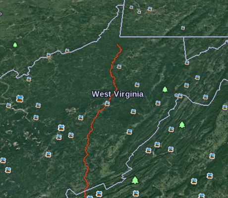
To make it easier for us to interpret the GIS information, Dr. Maxwell was kind enough to create a Google Earth file of the entire route (from Wetzel County, WV to Pittsylvania County, VA. He then created a buffer of 150 feet on each side of the route as this is the planned right-of-way during the construction phase of the project. To view this file, you will first need to download and install Google Earth — you can download it for free at: http://www.google.com/earth/download/ge/agree.html. Once you have downloaded Google Earth and installed it (or if you already have Google Earth installed), you will need to download the following file: http://preservethenrv.com/docs/MVP_Route.kmz. The file will download onto your computer. You can then Open the file (you will see the file name show at the bottom of your screen; click on the arrow to the right and select open) and it should open in Google Earth.

We are so lucky to have someone with Dr. Maxwell’s talents on our side — this resource will help landowners and citizens investigate the route better than the company’s maps.

A portion of the default view:

I’m going to be looking for places where accidental traffic congestion will delay construction. Critical sites that need re-routing will require boots on the ground to find and document those places. Got boots?
December 30, 2016

KML Documentation Introduction

Filed under: Google Earth,Google Maps,KML,Protests — Patrick Durusau @ 8:01 pm

KML Documentation Introduction

From the webpage:

If you’re new to KML, begin by browsing the KML Tutorial, which presents short samples of KML code that you can view in Google Earth.

The KML Reference provides detailed syntax for all KML elements, with explanations and diagrams of how to specify them.

The Developer’s Guide contains in-depth conceptual material and examples.

Creating and Sharing KML Files

You can create KML files with the Google Earth user interface, or you can use an XML or simple text editor to enter “raw” KML from scratch. KML files and their related images (if any) can be compressed using the ZIP format into KMZ archives. To share your KML and KMZ files, you can e-mail them, host them locally for sharing within a private internet, or host them publicly on a web server. Just as web browsers display HTML files, Earth browsers such as Google Earth display KML files. Once you’ve properly configured your server and shared the URL (address) of your KML files, anyone who’s installed Google Earth can view the KML files hosted on your public web server.

Many applications display KML, including Google Earth, NASA WorldWind, ESRI ArcGIS Explorer, Adobe PhotoShop, AutoCAD, and Yahoo! Pipes.

As a result of my data gathering on protests, I have acquired several GBs of KML files and links to many more.

Other resources you would suggest for coming up to speed on KML?

Thanks!

October 30, 2015

Amateur Discovery Confirmed by NASA

Filed under: Google Earth,History,Image Recognition — Patrick Durusau @ 1:45 pm

NASA Adds to Evidence of Mysterious Ancient Earthworks by Ralph Blumenthal.

From the post:

High in the skies over Kazakhstan, space-age technology has revealed an ancient mystery on the ground.

Satellite pictures of a remote and treeless northern steppe reveal colossal earthworks — geometric figures of squares, crosses, lines and rings the size of several football fields, recognizable only from the air and the oldest estimated at 8,000 years old.

The largest, near a Neolithic settlement, is a giant square of 101 raised mounds, its opposite corners connected by a diagonal cross, covering more terrain than the Great Pyramid of Cheops. Another is a kind of three-limbed swastika, its arms ending in zigzags bent counterclockwise.

Described last year at an archaeology conference in Istanbul as unique and previously unstudied, the earthworks, in the Turgai region of northern Kazakhstan, number at least 260 — mounds, trenches and ramparts — arrayed in five basic shapes.

Spotted on Google Earth in 2007 by a Kazakh economist and archaeology enthusiast, Dmitriy Dey, the so-called Steppe Geoglyphs remain deeply puzzling and largely unknown to the outside world.

Two weeks ago, in the biggest sign so far of official interest in investigating the sites, NASA released clear satellite photographs of some of the figures from about 430 miles up.

More evidence you don’t need to be a globe trotter to make major discoveries!

A few of the satellite resources I have blogged about for your use: Free Access to EU Satellite Data, Planet Platform Beta & Open California:…, Skybox: A Tool to Help Investigate Environmental Crime.

Good luck!

October 28, 2012

Displaying Your Data in Google Earth Using R2G2

Filed under: Google Earth,Visualization — Patrick Durusau @ 10:39 am

Displaying Your Data in Google Earth Using R2G2

From the post:

Have you ever wanted to easily visualize your ecology data in Google Earth? R2G2 is a new package for R, available via R CRAN and formally described in this Molecular Ecology Resources article, which provides a user-friendly bridge between R and the Google Earth interface. Here, we will provide a brief introduction to the package, including a short tutorial, and then encourage you to try it out with your own data!

Nils Arrigo, with some help from Loren Albert, Mike Barker, and Pascal Mickelson (one of the contributors to Recology), has created a set of R tools to generate KML files to view data with geographic components. Instead of just telling you what the tools can do, though, we will show you a couple of examples using publically available data. Note: a number of individual files are linked to throughout the tutorial below, but just in case you would rather download all the tutorial files in one go, have at it (tutorial zip file).

Among the basic tools in R2G2 is the ability to place features—like dots, shapes, or images (including plots you produced in R)— that represent discrete observations at specific geographical locations. For example, in the figure below, we show the migratory path of a particular turkey vulture in autumn of three successive years (red = 2009; blue = 2010; green = 2011).

Google Earth image with three successive years of a particular turkey vulture's migration

If researchers can track and visualize a single turkey vulture’s migration, across two continents, tracking and visualizing the paths, routes, and routines of other entities should be a matter of data collection.

October 11, 2012

…[A] Common Operational Picture with Google Earth (webcast)

Filed under: Geographic Data,Geographic Information Retrieval,Google Earth,Mapping,Maps — Patrick Durusau @ 10:01 am

Joint Task Force – Homeland Defense Builds a Common Operational Picture with Google Earth

October 25, 2012 at 02:00 PM Eastern Daylight Time

The security for the Asia-Pacific Economic Collaboration summit in 2011 in Honolulu, Hawaii involved many federal, state & local agencies. The complex task of coordinating information sharing among agencies was the responsibility of Joint Task Force – Homeland Defense (JTF-HD). JTF-HD turned to Google Earth technology to build a visualization capability that enabled all agencies to share information easily & ensure a safe and secure summit.

What you will learn:

  • Best practices for sharing geospatial information among federal, state & local agencies
  • How to incorporate data from many sources into your own Google Earth globe
  • How do get accurate maps with limited bandwidth or no connection at all.

Speaker: Marie Kennedy, Joint Task Force – Homeland Defense

Sponsored by Google.

In addition to the techniques demonstrated, I suspect the main lesson will be leveraging information/services that already exist.

Or information integration if you prefer a simpler description.

Information can be integrated by conversion or mapping.

Which one you choose depends upon your requirements and the information.

Reusable information integration (RI2), where you leverage your own investment, well, that’s another topic altogether. 😉

Ask: Are you spending money to be effective or spending money to maintain your budget relative to other departments?

If the former, consider topic maps. If the latter, carry on.

Powered by WordPress