Turf: GIS for web maps by Morgan Herlocker.
From the post:
Turf is GIS for web maps. It’s a fast, compact, and open-source JavaScript library that implements the most common geospatial operations: buffering, contouring, triangular irregular networks (TINs), and more. Turf speaks GeoJSON natively, easily connects to Leaflet, and is now available as a Mapbox.js plugin on our cloud platform. We’re also working to integrate Turf into our offline products and next-generation map rendering tools.
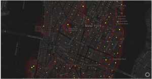
(Population data from the US Census transformed in read-time into population isolines with turf-isoline.)
The image in the original post is interactive. Plus there are several other remarkable examples.
Turf is part of a new geospatial infrastructure. Unlike the ArcGIS API for JavaScript, Turf can run completely client-side for all operations, so web apps can work offline and sensitive information can be kept local. We’re constantly refining Turf’s performance. Recent research algorithms can make operations like clipping and buffering faster than ever, and as JavaScript engines like V8 continue to optimize, Turf will compete with native code.
Can you imagine how “Steal This Book” would have been different if Abbie Hoffman had access to technology such as this?
Would you like to try? 😉