Uncovering Hidden Text on a 500-Year-Old Map That Guided Columbus by Greg Miller.
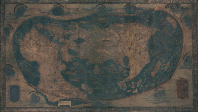
Christopher Columbus probably used the map above as he planned his first voyage across the Atlantic in 1492. It represents much of what Europeans knew about geography on the verge discovering the New World, and it’s packed with text historians would love to read—if only the faded paint and five centuries of wear and tear hadn’t rendered most of it illegible.
But that’s about to change. A team of researchers is using a technique called multispectral imaging to uncover the hidden text. They scanned the map last month at Yale University and expect to start extracting readable text in the next few months, says Chet Van Duzer, an independent map scholar who’s leading the project, which was funded by the National Endowment for the Humanities.
The map was made in or around 1491 by Henricus Martellus, a German cartographer working in Florence. It’s not known how many were made, but Yale owns the only surviving copy. It’s a big map, especially for its time: about 4 by 6.5 feet. “It’s a substantial map, meant to be hung on a wall,” Van Duzer said.
Extracting the text is going to take some effort but expectations are that high resolution images will appear at the Beinecke Digital Library at Yale in 2015.
Greg covers a number of differences between the Martellus map (1491) and the Waldseeüller map (1507), as well as their places in historical context.
You should pass this post onto any friends who think Columbus “discovered” the world was round. I don’t see any end of the world markers on the Martellus map.
Do you?