Another Word For It Patrick Durusau on Topic Maps and Semantic Diversity

January 29, 2017

Tracking DAPL Enablers – Bank of America Rogues Gallery

Filed under: #DAPL,Government,Politics,Protests — Patrick Durusau @ 2:16 pm

Continuing my list of co-conspirators financing in part the DAPL pipeline project. Number 2: Bank of America.

I was inspired to find more contacts by Emily Fuller’s How to Contact the 17 Banks Funding the Dakota Access Pipeline, which listed for Bank of America:

Bank of America

President, CEO, and Chairman Brian Moynihan

brian.t.moynihan@bankofamerica.com

Executive Relations, Office of the CEO:
Matthew Task
813-805-4873

Corporate Office:
100 N Tryon Street
Charlotte, NC 28255

(emphasis in original)

Bank of American maintains a rogues gallery of people to contact about its business and lending practices. Complete with photos should you happen to recognize one of them while shopping or in a crosswalk.

From Governance:

Biography Photo Brian Moynihan, Chairman of the Board and Chief Executive Officer, Bank of America Corporation
Biography Photo Jack O. Bovender, Jr., Lead Independent Director, Bank of America Corporation; Former Chairman and Chief Executive Officer, HCA, Inc.
Biography Photo Sharon L. Allen Former Chairman, Deloitte LLP
Biography Photo Susan S. Bies Former Member, Board of Governors of the Federal Reserve System
Biography Photo Frank P. Bramble, Sr. Former Executive Officer, MBNA Corporation
Biography Photo Pierre J. P. de Weck Former Chairman and Global Head of Private Wealth Management, Deutsche Bank AG
Biography Photo Arnold W. Donald President and Chief Executive Officer, Carnival Corporation & plc
Biography Photo Linda P. Hudson Chairman and CEO, The Cardea Group, and former President and CEO, BAE Systems Inc.
Biography Photo Monica C. Lozano Former Chairman, US Hispanic Media Inc.
Biography Photo Thomas J. May Chairman, Eversource Energy
Biography Photo Lionel L. Nowell, III Former Senior Vice President and Treasurer of PepsiCo, Inc.
Biography Photo Michael D. White Former Chairman, President and Chief Executive Officer of DIRECTV
Biography Photo Thomas D. Woods Former Vice Chairman and SEVP, Canadian Imperial Bank of Commerce
Biography Photo R. David Yost Former Chief Executive Officer, AmerisourceBergen Corporation

In addition, the governance page notes:

Persons seeking to communicate with the Board of Directors, any director, non-management members of the Board as a group or any committee of the Board should send a letter to the Corporate Secretary at Bank of America Corporation, 214 N. Tryon St., NC1-027-20-05, Charlotte, NC 28255. The letter should indicate to whom the communication is intended. The Corporate Secretary or the secretary of the designated committee may sort or summarize the communications as appropriate. Communications that are commercial solicitations, customer complaints, incoherent or obscene will not be communicated to the Board or any director or committee of the Board.

Bank of America Executive:

From executive biographies:

Dean Athanasia Dean Athanasia, President of Preferred and Small Business Banking and Co-head of Consumer Banking, Bank of America
Cathy Bessant Catherine P. Bessant, Chief Operations and Technology Officer, Bank of America
Sheri Bronstein Sheri B. Bronstein, Global Human Resources Executive, Bank of America
Paul Donofrio Paul Donofrio, Chief Financial Officer, Bank of America
Anne Finucane Anne M. Finucane, Vice Chairman, Bank of America
Geoffrey Greener Geoffrey S. Greener, Chief Risk Officer, Bank of America
Christine Katziff Christine P. Katziff, Corporate General Auditor, Bank of America
Terry Laughlin Terry Laughlin, Vice Chairman and Head of Global Wealth and Investment Management, Bank of America
David Leitch David G. Leitch, Global General Counsel, Bank of America
Gary Lynch Gary G. Lynch, Vice Chairman, Bank of America
Tom Montag Thomas K. Montag, Chief Operating Officer, Bank of America
Thong Nguyen Thong M. Nguyen, President of Retail Banking and Co-head of Consumer Banking, Bank of America
Andrea Smith Andrea B. Smith, Chief Administrative Officer, Bank of America
Bruce Thompson Bruce R. Thompson, Vice Chairman, Bank of America

Searching the Bank of America website, I could find no mention of DAPL or Energy Transfer Equity, etc.

I have a dawning suspicion that the information wasn’t being hidden but that such crimes are so commonplace as to be unremarkable in the Bank of American worldview. More on that in a separate post.

January 28, 2017

Tracking DAPL Enablers – ABN Amro Capital USA LLC.

Filed under: #DAPL,Government,Politics,Protests — Patrick Durusau @ 5:34 pm

The Energy Trasfer Equity SEC 8-K filing lists the following co-conspirators who are financing, in part, the DAPL pipeline project:

  • ABN Amro Capital USA LLC.
  • Bank of America, N.A.
  • Barclays Bank PLC
  • The Bank of Tokyo Mitsubishi UFJ, Ltd.
  • BNP Paribas
  • Citibank, N.A.
  • Compass Bank
  • Credit Agricole Corporate and Investment Bank
  • Credit Suisse AG, Cayman Islands Branch
  • Deutsche Bank AG New York Branch
  • DNB Bank ASA, Grand Cayman Branch
  • Goldman Sachs Bank USA
  • HSBC Bank USA, National Association
  • ING Capital LLC
  • Intesa Sanpaolo S.P.A., New York Branch
  • JPMorgan Chase Bank, N.A.
  • Mizuho Bank, Ltd.
  • Morgan Stanley Senior Funding, Inc.
  • Natixis, New York Branch
  • PNC Bank, National Association
  • Royal Bank of Canada
  • The Royal Bank of Scotland PLC
  • Sumitomo Mitsui Banking Corporation
  • SunTrust Bank
  • UBS AG, Stamford Branch
  • Wells Fargo Bank, N.A.

How to Contact the 17 Banks Funding the Dakota Access Pipeline by Emily Fuller provides valuable contact information but much more can be had.

Starting from the top with ABN Amro Capital USA LLC., Bloomberg says (as of 28 January 2017):

ABN Amro Capital USA LLC offers commercial banking services. The company was incorporated in 2009 and is based in New York, New York. ABN Amro Capital USA LLC operates as a subsidiary of ABN AMRO Group N.V.

100 Park Avenue
Floor 17
New York, NY 10017
United States

Founded in 2009

Phone: 212-649-5100
Fax: 917-284-6697

Key Executives For ABN Amro Capital USA LLC

ABN Amro Capital USA LLC does not have any Key Executives recorded.

Turning to ABN AMRO Group N.V., Bloomberg reports in part:

ABN AMRO Group N.V.

January 28, 2017 1:42 PM ETBanks
Company Overview of ABN AMRO Group N.V.
Snapshot

Company Overview

ABN AMRO Group N.V. provides banking products and services for retail, private, and corporate banking customers in the Netherlands and internationally. […] ABN AMRO Group N.V. was incorporated in 2009 and is headquartered in Amsterdam, the Netherlands.

Gustav Mahlerlaan 10
Amsterdam, 1082 PP
Netherlands

Founded in 2009
21,809 Employees

Phone: 31 09 000 024
www.abnamro.com

People:

Key Executives For ABN AMRO Group N.V.

Mr. Kees C. van Dijkhuizen
Chairman of the Managing Board and Chief Executive Officer
(…)

Mr. Johan van Hall
Vice Chairman of the Managing Board and Chief Operating Officer
(…)

Mr. Wietze Reehoorn
Chief Risk Officer and Member of the Managing Board
(…)

Ms. Caroline E. Princen
Executive Officer
(…)

Mr. Chris F. H. H. Vogelzang
Member of the Managing Board
(…)

In addition to the identity of the chief officers of this miscreant, we now know of some 21,089 (as of 2015) employees who may be more environmentally conscious than their masters. Enabling poisoning of water along a 1,172-mile-long pipeline is no small thing.

The ABN AMRO Annual Report 2015 lists the managing board as:

  • Gerrit Zalm (chair)
  • Johan van Hall (vice-chair)
  • Kees van Dijkhuizen
  • Caroline Princen
  • Wietze Reehoorn
  • Chris Vogelzang
  • Joop Wijn

(at page 119)

Member of the supervisory board as:

  • Rik van Slingelandt (chair)
  • Hans de Haan
  • Bert Meerstadt
  • Annemieke Roobeek
  • Rik van Slingelandt
  • Steven ten Have
  • Olga Zoutendijk

(at page 281)

A presentation from May of 2016 reports the election of the following to the supervisory board:

A.C. Dorland

Ms F.J. Leeflang

J.S.T. Tiemstra

A presentation from August of 2016 reports Olga Zoutendijk is Chairman of the Supervisory Board and the appointment of: Mr. Jurgen Stegmann to the supervisory board.

The present composition of either board isn’t entirely clear from records on the company website but current member or no, the individuals listed no doubt have useful information/insight to share about the company.

For general contact purposes, the company website offers:

If you have questions about ABN AMRO Group’s financials, business activities, capital, funding, credit ratings or related issues, please contact our Investor Relations team.

E-mail investorrelations@nl.abnamro.com

Phone: +31 20 628 22 82

Dies Donker

Head of Investor Relations

+31 (0)20 383 05 17

Ruud Jaegers

Deputy Head of Investor Relations

+31 (0)20 383 58 36

Niels Farragher

Investor Relations

+31 (0)20 343 49 82

Anton Groenevelt

Investor Relations

+31 (0)20 628 25 86

Annedien Heilbron

Investor Relations

+31 (0)20 383 72 44

Jan-Willem Stokhuyzen

Investor Relations Analyst

+31 (0)20 343 94 88

Geeta Ramkhelawan

Secretary

+31 (0)20 383 32 35

Suggestions improving upon this starting point:

First, the company website claims a presence in Asia, Australia, Europe, North American and South American so you should have little difficulty finding one or more of those 21,089 employees (as of 2015) who can impact ABN Amro’s participation in this environmental outrage.

Second, I have kept copies of the various corporate documents should the links to resumes fall prey to link rot or other mishaps. Those may be useful in identifying specific individuals.

Third, this surface examination of ABN Amro and those of the other listed enablers to follow, are a prelude to exploring the recursive question: Who owns the enablers?

January 26, 2017

Contacting Bank Owners – Funding DAPL

Filed under: #DAPL,Government,Politics,Protests — Patrick Durusau @ 5:58 pm

Yesterday I posted a useful list of banks funding DAPL, Contacting the 17 Banks Funding the Dakota Access Pipeline, created by Emily Fuller.

Emily points out some banks are dodging public comment on their investments.

Banks are toadies for their owners and if you can persuade their owners, the banks will dance another tune.

Discovering the owners of banks, human owners, isn’t a straight forward task.

Tables adapted from MorningStar provide a starting place, show the ownership of Wells Fargo (#1 on Emily’s list) by institutions and funds, as:

Institutions

Name Shares Held % Total
Shares Held
Berkshire Hathaway Inc 479,704,270 9.55
Vanguard Group Inc 293,529,151 5.84
BlackRock Fund Advisors 159,579,472 3.18
State Street Corp 144,304,075 2.87
Fidelity Management and Research Company 114,390,616 2.28
Wellington Management Company LLP 105,287,458 2.10
Columbia Insurance Company 74,533,819 1.46
Capital World Investors 87,714,669 1.75
J.P. Morgan Investment Management Inc 71,187,640 1.42
National Fire & Marine Insurance Co 55,776,330 1.10
Dodge & Cox 67,255,750 1.34
Northern Trust Investments N A 60,080,126 1.20
State Street Global Advisors (Aus) Ltd 50,252,360 1.00
State Farm Mutual Automobile Ins Co 55,039,014 1.10
MFS Investment Management KK 49,919,843 0.99
Geode Capital Management, LLC 39,689,832 0.79
Government Pension Fund of Norway – Global 38,048,678 0.72
Barrow Hanley Mewhinney & Strauss LLC 37,011,768 0.74
T. Rowe Price Associates, Inc. 31,739,499 0.63
TIAA-CREF Investment Management LLC 27,710,384 0.55

Funds

Name Shares Held % Total
Shares Held
Vanguard Total Stock Mkt Idx 95,774,705 1.91
Vanguard 500 Index Inv 66,073,771 1.32
SPDR® S&P 500 ETF 50,880,290 1.01
Vanguard Institutional Index I 49,389,580 0.98
Fidelity® Contrafund® 48,971,538 0.98
Dodge & Cox Stock 43,253,341 0.86
Financial Select Sector SPDR® ETF 34,990,492 0.69
Vanguard Wellington™ Inv 34,242,007 0.68
VA CollegeAmerica WA Mutual 529B 26,217,100 0.52
MFS Value A 25,832,081 0.51
Fidelity Spartan® 500 Index Inv 25,067,450 0.50
VA CollegeAmerica Amercn Bal 529E 23,103,000 0.46
VA CollegeAmerica Inc Fund of Amer 529E 21,980,915 0.44
Vanguard Value Index Inv 21,264,834 0.42
Franklin Income A 20,000,000 0.40
CREF Stock R1 20,598,209 0.41
Vanguard Windsor™ II Inv 20,343,696 0.40
iShares Russell 1000 Value 14,316,510 0.28
Vanguard High Dividend Yield ETF 13,351,361 0.27
Parnassus Core Equity Investor 13,218,831 0.26

If these ownership tables look like, appear to be, the sort of relationship information that can be captured by a graph, topic map, etc., you are right in one!

Moreover, the ownership information of other funding banks, such as SunTrust Banks Inc., shows a number of institutions and funds in common.

Meaning that if we pierce the corporate veil and get the names of people, as officers, board of directors, shareholders, etc. those will be valid for one or more of the other funding banks for DAPL as well.

A graph of human owners for a bank, will intersect and overlay other ownership graphs for other banks, enabling activists to focus on persuading the most influential human owners.

Discussion of identifiers for the owners you see listed in this post coming tomorrow!

PS: Consider this a continuation of: Refining The Dakota Access Pipeline Target List. I got distracted by a number of things. Sorry!

January 20, 2017

Trump Inauguration Police Tactics/Blockades – 10:30 AM EST

Filed under: Politics,Protests — Patrick Durusau @ 10:30 am

Unicorn Riot is live streaming protests, including checkpoint blockades, from Washington, D.C.

An interesting variation on the police formation I detailed in Defeating Police Formations – Parallel Distributed Protesting, the police are breaching the blockade single file to create a path for people who want to attend the inauguration.

An odd reverse of the “surge and arrest” tactic to “surge and enable passage.”

The inauguration is still two hours out.

Join Unicorn Riot, Democracy Now! or one of the other live streams covering protests.

Personally I have no interest in the “official” ceremonies and will be skipping those.

PS: A tweet as of 35 minutes ago reports (unconfirmed) that 6 of 12 inauguration entrances have been completely shut down and traffic at others slowed to a “trickle.”

January 19, 2017

Permitted Trump Protesters Will Be Ignored

Filed under: Government,Politics,Protests — Patrick Durusau @ 2:52 pm

I wish my headline was some of the “fake news” Democrats complain about but Alexandra Rosemann proves the truth of that headline in:

Ignoring anti-Trumpers: Why we can expect media blackout of protests against Trump’s inauguration.

Not ignored by just anybody, ignored by the media.

On Jan. 20 — 16 years ago — thousands of protesters lined the inauguration parade route of the incoming Republican president. “Not my president,” they chanted. But despite the enormity of the rally, it was largely ignored. Instead, pundits marveled over how George W. Bush “filled out the suit” and confirmed authority.

“The inauguration of George W. Bush was certainly a spectacle on Inauguration Day,” marvels Robin Andersen, the director of Peace and Justice studies at Fordham University, in the 2001 short documentary “Not My President: Voices From the Counter Coup.”

It’s nearly impossible not to anticipate the eerie parallels between George W. Bush’s inauguration and that of Donald Trump.

“Forty percent of the public still believed that Bush had not been legitimately elected, yet there’s almost no discussion of these electoral problems or the constitutional crisis,” Andersen explains in the film. “Instead, Bush undergoes a kind of transformation where he fills out the suit and becomes a leader. Forgotten are any of the questions about his ability, his experience or his mangling of the English language. His transformation is almost magical,” she adds.

Andersen estimated the inauguration protests, which occurred throughout the country, garnered approximately 10 minutes of total coverage on all the major networks.

“When we did see images of protesters, there was no explanation as to why. We were asked to be passive spectators in this ritual of legitimation when the real democratic issues that should have been being discussed were ignored,” Andersen says in the film, reflecting on the “real democracy” in the streets of Washington, D.C.

Your choice. Ten minutes of coverage out of over 24 hours of permitted protesting, or the media covering a 24 hour blockade of the DC Beltway.

fox5dc-map-460

Which one do you think draws more attention to your issues?

A new president will be inaugurated on January 20, 2017, but its your choice whether its him, his wife and a few cronies in attendance or hundreds of thousands.

See protests for more ideas on that possibility.

January 18, 2017

Resistance Manual / Indivisible

Filed under: Government,Politics,Protests — Patrick Durusau @ 1:40 pm

Resistance Manual

An essential reference for the volatile politics of the Trump presidency.

Indivisible

Four former congressional staffers banded together to write: “A practical guide to resisting the Trump Agenda.”

Both are shaped by confidence in current political and social mechanisms, to say nothing of a faith in non-violence.

Education is seen as the key to curing bigotry/prejudice and moving towards a more just society.

You will not find links to:

Steal this Book or the Anarchist Cookbook, 2000 edition for example.

There are numerous examples cited as “successful” non-violent protests. The elimination of de jure segregation in the American South. (Resource includes oral histories of the time.)

But, de facto segregation in schools is larger than it was in the 1960’s.

How do you figure that into the “success” of non-violent protests?

Read both Resistance Manual and Indivisible for what may be effective techniques.

But ask yourself, do non-violent protests comfort the victims of violence?

Or just the non-violent protesters?

January 16, 2017

Defeating Police Formations – Parallel Distributed Protesting

Filed under: Politics,Protests — Patrick Durusau @ 2:58 pm

If you haven’t read FEMA’s Field Force Operations PER-200, then you are unprepared for #DisruptJ20 or any other serious protest effort.

It’s a real snore in parts, but knowing police tactics will:

  1. Eliminate the element of surprise and fear of the unexpected
  2. Enable planning of protective clothing and other measures
  3. Enable planning of protests to eliminate police advantages
  4. Enable protesters to respond with their own formations

among other things.

On Common Police Formation

While reading Field Force Operations PER-200, I encountered several police formations you are likely to see at #DisruptJ20.

The crossbow arrest formation is found at pages 48-49 and illustrated with:

cross-bow-01-460

cross-bow-02-460

cross-bow-03-460

A number of counter tactics suggest themselves, depending upon your views on non-violence. Passive resistance by anyone who is arrested, thereby consuming more police personnel to secure their arrest. Passively prevented the retreat of the arrest team and its security circle. Breaching the skirmish line on either side of the column, just before the column surges forward, exposing the flank of the column.

Requirements for the crossbow arrest formation

What does the crossbow arrest formation require more than anything else?

You peeked! 😉

Yes, the police formations in Field Force Operations PER-200, including the crossbow arrest formation all require a crowd.

Don’t get me wrong, crowds can be a good thing and sometimes the only solution. Standing Rock is a great example of taking and holding a location against all odds.

But a great tactic for one protest and its goals, may be a poor tactic for another protest, depending upon goals, available tactics, resources, etc.

Consider the planned and permitted protests for #DisruptJ20.

All are subject to the police formation detailed by FEMA and the use of “less lethal” force by police forces.

How can #DisruptJ20 demonstrate the anger of the average citizen and at the same time defeat police formations?

Parallel Distributed Protesting

Instead of massing in a crowd, where police formations and “less lethal” force are options, what if protesters stopped, ran out of gas, had flat tires on the 64-mile DC Beltway.

I mention the length of the Beltway, 64 miles, because it is ten miles longer than marches from Montgomery to Selma, Alabama. You may remember one of those marches, it’s documented at The incident at the Edmund Pettus Bridge.

On March 7, 195, Representative John Lewis, Hosea Williams and other protesters marched across the Pettus bridge knowing that brutality and perhaps death awaited them.

Protesters who honor Lewis, Williams and other great civil rights leaders can engage in parallel distributed protesting on January 20, 2017.

Each car slowing, stopping, having a flat tire, is a distributed protest point. With distributed protest points occurring in parallel, the Beltway grinds to a halt. No one enters or leaves Washington, D.C. for a day.

Not the same as the footage from the Pettus Bridge, but shutting down the D.C. Beltway will be a news story for months and years to come.

fox5dc-map-460

Lewis, Williams and others were willing to march into the face violence and evil, are you willing to drive to the D.C. Beltway to stop, run out of gas or have a flat tire in their honor?

PS: Beltway blockaders should always be respectful of police officers. They probably don’t like what is happening any more than you do. Besides, their police cruisers are also blocking traffic so their presence is contributing to the gridlock as well.

January 15, 2017

Phishing As A Public Service – Leak Access, Not Data

Filed under: Government,Politics,Protests — Patrick Durusau @ 5:23 pm

The Intercept tweeted today:

intercept-460

Kudos to The Intercept for reaching out to (US) federal employees to encourage safe leaking.

On the other hand, have you thought about the allocation of risks for leaking?

Take Edward Snowden for example. If caught, Snowden is going to jail, NOT Glenn Greenwald or other reporters who used the Snowden leak.

The Intercept has a valid point when it says:


Without leaks, journalists would have never connected the Watergate scandal to President Nixon, or discovered that the Reagan White House illegally sold weapons to Iran. In the past 15 years alone, inside sources played a vital role in uncovering secret prisons, abuses at Abu Ghraib, atrocities in Afghanistan and Iraq, and mass surveillance by the NSA.

At least historically speaking. Back in the days when hard copy was the norm.

Hard copy isn’t the norm now and leaking guidelines need to catch up to the present day.

Someone could have leaked a portion of the Office of Personnel Management records but in a modern age, digital was far more powerful. (That was a straight hack but it illustrates the difference between sweaty smuggling of hard copy versus giving others the key to a vault.)

If instead of leaking documents/data, imagine following these instructions:

The best option is to use our SecureDrop server, which has the advantage of allowing us to send messages back to you, while allowing you to remain totally anonymous — even to us, if that is what you prefer.

  • Begin by bringing your personal computer to a Wi-Fi network that isn’t associated with you or your employer, like one at a coffee shop. Download the Tor Browser. (Tor allows you to go online while concealing your IP address from the websites you visit.)
  • You can access our SecureDrop server by going to http://y6xjgkgwj47us5ca.onion/ in the Tor Browser. This is a special kind of URL that only works in Tor. Do NOT type this URL into a non-Tor Browser. It won’t work — and it will leave a record.
  • If that is too complicated, or you don’t wish to engage in back-and-forth communication with us, a perfectly good alternative is to simply send mail to P.O. Box 65679, Washington, D.C., 20035, or to The Intercept, 114 Fifth Avenue, 18th Floor, New York, New York, 10011. Drop it in a mailbox (do not send it from home, work or a post office) with no return address.

And you send the following:

  1. Your email address
  2. Screen shots of legitimate emails you get on a regular basis
  3. What passwords are the most important

That’s it.

The receiver constructs a phishing email and sends it to your address.

Like John Podesta and numerous other public figures, you are taken in by this scam.

Evil doers use your present password for access and you have system recorded evidence that you were duped.

How does that allocation of risk look to you, as a potential leaker?

PS: Some, but not all, journalists will be quick to point out what I suggest is, drum roll, illegal. OK, and the question?

Those journalists are being very brave on behalf of leakers, knowing they will never share the fate of a leaker.

I make an exception for all the very brave journalists writing outside of the United States and a few other areas at great personal risk. But then they are unlikely to be concerned with the niceties of the law when dealing with a rogue government.

Update: Apologies but I forgot to include a link to the original post: Attention Federal Employees: If You See Something, Leak Something.

Thoughts on Blockading Metro Rail Stops

Filed under: Government,Politics,Protests — Patrick Durusau @ 3:38 pm

A recent news report mentioned the potential for blockades of DC Metro Rail stops.

Curbed Washington DC posted a list of those stops, but like many reporters, did not provide links to the stops.

🙁

Here’s their list:

metro-stops-460

Metro Stops with Hyperlinks

Here’s my version, in the same ticket color order:

Presented as the original, the list leaves the impression of more Metro stops than require blockading. Here is “apparent” count of Metro Stops is twelve (12).

Discovering Duplicate Metro Rail Stops

Rearrangement by Metro Rail stops reveals duplicates:

Deduped Metro Stops and Priority Map

If we remove the duplicate stops and sort by stop name, we find only eight (8) Metro Stops for blockading.

  1. Capital South Green Ticket Holders
  2. Eastern Market Green Ticket Holders
  3. Federal Center SW Orange Ticket Holders, Silver Ticket Holders
  4. Gallery Place-Chinatown Blue Ticket Holders, Red Ticket Holders
  5. Judiciary Square Blue Ticket Holders, Red Ticket Holders
  6. L’Enfant Plaza Orange Ticket Holders, Silver Ticket Holders
  7. NoMa-Gallaudet U Yellow Ticket Holders
  8. Union Station Yellow Ticket Holders

All of this is public information and with a little rearrangement, it becomes easier to focus resources on any potential blockading of those stops.

In terms of priorities, Curbed Washington DC posted a map of the gate locations and guest sections for ticket holders. I took a screen-shot of the center portion:

guest-sections-460

If your are interested in activities around the checkpoints, see the larger map.

So You Want To Blockade A Metro Stop

A map of Union Station reminded me that open street blockading isn’t likely to close a Metro Rail stop.

Why? Even with a large number of hardened protesters, the police can approach you from all sides, driving you in particular directions with “less lethal” weapons.

But the architecture of a Metro Rail stop offers an alternative strategy to open air resistance.

Don’t blockade outside a Metro Rail stop, blockade the stop by occupying stairwells, access points, etc.

Anyone opposing the blockade will seek to restore service and so be less likely to use persistent gases or other irritants in closed spaces.

The other advantage of escalators, stairways is that the police can only approach from in front or from behind you. Enabling you to defend the edges of your formation with layers of the most recalcitrant protesters.

I know you intend to peacefully and lawfully assemble only but be aware you may have those in your midst who damage and/or disable turnstiles. Either with some variety of fast acting adhesives or jamming them with thin metallic objects. Although illegal, those acts will also contribute to delaying the restoration of full service.

More thoughts on blockades reduce the number of people reaching Metro Rail stops tomorrow.

PS: It’s unfortunate the Metro doesn’t use tokens anymore. There are some interesting things that can happen with tokens.

January 12, 2017

Inaugural Ball Cancellation!

Filed under: Politics,Protests — Patrick Durusau @ 5:26 pm

Your antipathy towards upcoming inaugural balls and work on possible blockades is having an impact!

The Arkansas Inaugural Ball has been cancelled do to “low demand.”

The listing of inauguration balls I pointed to yesterday has plenty of other places for blockades and other mischief.

Looking forward to the least attended inauguration in history, longest and largest traffic snarl in history and complete social disasters at the inauguration balls.

January 11, 2017

Flashing/Mooning For Inauguration Forecast

Filed under: Politics,Protests — Patrick Durusau @ 9:55 pm

You can find updated weather forecast for January 20, 2017, updated from my speculations in Blockading Washington – #DisruptJ20 – Unusual Tactic – Nudity in Angela Friz’s Here’s the first of what will surely be many inauguration weather forecasts.

Angela isn’t reporting sun-bathing weather but warm enough that a heavy coat over your birthday suit may be sufficient.

Of course, you could always build a fire in a trash barrel, something we are likely to see a lot of during the Trump presidency.

I’m sure other protesters, in the buff or not will appreciate the extra warmth.

Missing The Beltway Blockade? Considering Blockading A Ball?

Filed under: Data Science,Politics,Protests — Patrick Durusau @ 7:18 pm

For one reason or another, you may not be able to participate in a Beltway Blockade January 20, 2017, see:

Don’t Panic!

You can still enjoy a non-permitted protest and contribute to the least attended inauguration in history!

2017 Presidential Inaugural Balls

The list is short on location information for many of the scheduled balls but the Commander in Chief’s Ball, Presidential Inaugural Ball, Mid-Atlantic Inauguration Ball, Midwest Inaugural Ball, Western Inaugural Ball, and the Neighborhood Inaugural Ball, are all being held at the: Walter E. Washington Convention Center.

Apologies but I haven’t looked up prior attendance records but just based on known scheduling, disruption in the area of Walter E. Washington Convention Center looks like it will pay the highest returns.

For the balls with location information and/or location information that I can discover, I will post a fuller list with Google Map links tomorrow.

Oh, for inside protesting, here are floor plans of the Walter E. Washington Convention Center.

Those are the official, posted floor plans.

Should that link go dark, let me know. I have a backup copy of them. 😉

January 9, 2017

ANSWER Secures More “Permitted” Protest Space

Filed under: Government,Politics,Protests — Patrick Durusau @ 9:01 pm

inaugurate-banner-460

The ANSWER Coalition has:

…secured another permitted assembly area for an even larger gathering site on the parade route, the Navy Memorial (8th St. and Pennsylvania Ave. NW).

See: ANSWER Coalition for details and ways to support.

If your not interested in “permitted” protesting, it could be the case that attendees and protesters alike find it difficult if not impossible to attend the inauguration. See protests for an ongoing series of speculations in that direction.

PS: I remember the Constitution reading:

Congress shall make no law … abridging…the right of the people peaceably to assemble…

NOT:

Congress shall make no law … abridging…the right of the people to be permitted to assemble…

Do you?

January 7, 2017

> 3000 for 2017? – Defining Blockade Success

Filed under: Government,Politics,Protests — Patrick Durusau @ 4:41 pm

Trump Inauguration Planners Unveil Tickets, Map says:


About 3,000 people holding purple tickets got stuck on foot in the Interstate 395 tunnel when trying to attend President Barack Obama’s first inauguration, causing many of them to miss the ceremony. The tunnel was later nicknamed the Purple Tunnel of Doom.

Data science projects should define criteria for success, before the project starts.

That helps prevent management from moving the goal posts to claim victory where none exists and protects you from “but it doesn’t ….” when that feature wasn’t included in the criteria for success.

In efforts to #DisruptJ20 the Trump inauguration, it appears that at least 3K people must be prevented from reaching the inauguration.

For your planning purposes, the 2017 SWEARING IN CEREMONY INFORMATION (FAQ) advises:


What time should I get to the US Capitol for the ceremony?

The gates to the mall will most likely open at 5:00am, and the ticketed areas are usually filled by 8:00am. The ceremony will begin around 11:30am with a musical performance prior to that time.

Blockaders are in for a long night!

The rate of removal of cars that intentionally or unintentionally run out of gas, disabled vehicles (think flat tires), etc., is unknown.

As a guesstimate, I would say gridlock conditions starting around 3 AM and persisting until NOON, EST, would result in an inauguration to which a majority of the ticket holders did not attend.

I wonder if the news channels will focus more on protesters or empty bleachers? Guesses?

Implementing Indivisible – Early Difficulties

Filed under: Politics,Protests — Patrick Durusau @ 3:59 pm

Indivisible (Indivisible: A Practical Guide for Resisting the Trump Agenda recommends appearing at every public appearance of your representative.

The same logic to other representatives since their committees votes on issues that impact you.

Question: How do you find all the offices of members of the US House or Senate?

Answer: Not easily.

Take Senator Diane Feinstein for example.

First source

http://bioguide.congress.gov/scripts/biodisplay.pl?index=F000062 gives:

bioguide-feinstein-460

Second Source

GPO Congressional Directory provides:

gpo-feinstein-460

Third Source

https://www.congress.gov/member/dianne-feinstein/F000062 lists:

members-feinstein-460

Local office information appears at Senator Diane Feinstein, but its listing varies from page to page, making automated extraction an iffy proposition.

Empowering Indivisible

Congress is sorely in need of a topic map for its members, that much is obvious.

What does the lack of an easy way to local office information suggest to you?

Would local office information improve your odds of contacting your own representative and others?

January 5, 2017

ANSWER Protest Permit – Least Attended Inauguration in History

Filed under: Government,Politics,Protests — Patrick Durusau @ 8:46 pm

Permits secured for Jan. 20 Mass Protest at the Inauguration!

From the post:


The ANSWER Coaltion has a permit for 14th street and Pennsylvania Ave NW and a portion of Freedom Plaza, beginning at 7:00am on Jan. 20 for a protest that will continue throughout the day.

We are also continuing our long legal battle for additional permitted space along Pennsylvania Ave. on Inauguration Day. The National Park Service has stonewalled the issuance of additional permits in an attempt to sanitize the most visible and primary locations along the route from dissent and free speech activity. Additionally, we are continuing to challenge the illegal, unconstitutional system whereby NPS reserves large portions of the route and other parts of D.C. on Inauguration Day, and in the days and weeks prior to and after, on behalf of Trump’s Presidential Inaugural Committee.

We think it’s critically important for the people to not be intimidated, to not be silent and to use all public spaces to express themselves.

(emphasis in original)

All of that is true, but attending the ANSWER protest means you will be counted as “attending the inauguration.”

What if you took ANSWER’s later advice:

use all public spaces to express themselves.

With tailgate parties on the Beltway (Tailgating @DisruptJ20), and blockades of the same (Low Risk Blockading of the DC Beltway).

Secure President-elect Trump’s place in the history books, with the least attended inauguration in history.

You can be part of that historical event, while sitting on the Beltway out of gas.

Which is it? Do you want to be “in attendance” or “truant” for Trump’s inauguration?

January 4, 2017

FEMA – HOW-TO Demonize Your Opponents

Filed under: Government,Politics,Protests — Patrick Durusau @ 11:55 am

Beryl Lipton writes in FEMA Field Force manual offers protesters insights into the future of crowd control:

Though construction on the Dakota Access Pipeline has halted for now, the lessons for law enforcement and protesters are still percolating. For the former, they’ll likely find themselves one day studying the event as they prepare for future mass gatherings, maybe in a guide just like the one distributed by the Federal Emergency Management Agency (FEMA) to North Dakota law enforcement in September.

… (graphic of DHS omitted)

Obtained by Unicorn Riot via a request to the North Dakota Department of Corrections, an agency with far fewer individuals in its custody than attended the protest at Standing Rock, the manual is a Field Force Operations training program for students, a crash course in eight parts on how to deal with a mixed crowd of lawful and unlawful dissenters.

I extracted the Field Force Operations PER-200 manual, from the zip file posted at MuckRock for your reading/access convenience.

As a government training document, allegedly “our” government, the manual fails in a number of aspects.

Consider its efforts to demonize protesters:


b. Protesters. Not every protester is the same nor should be viewed the same by law enforcement. By better understanding protesters, law enforcement officers can make better choices on how to respond. A small group of unruly protesters can stand out from the peaceful majority—often comprised of others who just want to be there along with innocent bystanders accidentally caught in the melee.

(1) Everyday citizens. Most protests include everyday citizens gathering through their First Amendment right to peaceably make their voices heard (Driscoll, 2003).

(2) Professional protesters. These people train or are trained in protester tactics often by direct action organizations that promote two universal messages: First, intervention demands responsibility. Second, a smaller harm is acceptable if it prevents a greater harm. One interpretation of this second message is that it is acceptable for protesters to break laws they consider less important like vandalism to prevent a greater harm like environmental damage. Some activism organizations may produce booklets that demonstrate use or construction of devices, including the infamous Road Raging – Top Tips for Wrecking Roadbuilding (Road Alert!, 1997).

(3) Anarchists. These people aim to disrupt, often seeking to challenge authority and capitalism at any cost. They are frequently young college students who express themselves through the destruction of property. Anarchists may mix into peaceful protests despite the efforts of the nonviolent protesters to limit destructive activities—leading to fighting sometimes between protesters. One common anarchist technique is the black bloc (violent, destructive activity), demonstrated at the Occupy Seattle protests.
… (at page 106)

If you think that lacks a charitable attitude towards ordinary people out-raged as some government misconduct, consider this listing of the “types” of individual protesters:


(1) Impulsive. These short-tempered people are the kind who are always spoiling for a fight and only need a fancied insult or a slight provocation to excite them to violence or incite others to violence.

(2) Suggestible. People who get into the action early and are easily influenced to follow the lead of the more violent.

(3) Cautious. Individuals who wait for the cloak of anonymity to give them courage by hiding their identity.

(4) Yielders. Those who do not join the action until a large number of participants give the impression of universality. In other words, “Everyone is taking part, so why shouldn’t I?”

(5) Supportive. People who do not actively join the mob but who enjoy the show and even shout encouragement.

(6) Resisters. Persons whose standards of judgment are not swayed by the emotional frenzy of the mob but who maintain level heads. They can disagree with the actions of the majority.

(7) Psychopathic. Individuals with a pathological personality structure are angry at the world and seek to use a riotous situation as a means of getting even with society (FBI, 1967, p. 21).
… (page 108)

How’s that for a rhetorical move?

In three pages the reader is drawn from “everyday citizens” to a range of personality disorders that range up to the “psychopathic.”

Any reader instinctively feels a gathering of protesters is a boiling pot of crazy ready to explode.

A false worldview but one promoted by the FEMA manual.

Imagine you are a local law enforcement officer, with little or no personal experience with civil disobedience, being told by FEMA that protesters are the harbingers of chaos. What’s your reaction going to be?

It’s only one example but Julia Carrie Wong and Sam Levin report in: Standing Rock protesters hold out against extraordinary police violence:


Harkening back to an earlier era, when police in Birmingham, Alabama, attacked African American schoolchildren with dogs and high-pressure water hoses, North Dakota officers trained water cannons on hundreds of Dakota Access pipeline protesters.

On the night of 20 November, though, the temperature was below freezing and the protesters, who call themselves “water protectors”, were camping outdoors for the evening.

Water is just one many “less-than-lethal” munitions that have been trained against the activists.

“They seem to have almost an infinite arsenal of different types of weapons,” said Rachel Lederman, attorney for the National Lawyers Guild (NLG). “I don’t think local law enforcement understands how dangerous they are.”

Police have acknowledged using sponge rounds, bean bag rounds, stinger rounds, teargas grenades, pepper spray, Mace, Tasers and a sound weapon. The explosive teargas grenades in use at Standing Rock have been banned by some US law enforcement agencies because they indiscriminately spray people, Lederman said.

More than two dozen people were hospitalized and 300 injured during the conflict, according to the medic and healer council. One woman’s arm was nearly blown off, according to her father, and the complaint alleges that another woman was shot in the eye, resulting in the detachment of her retina and possible permanent blindness.

Question: Should “everyday citizens” be sprayed with water cannon in sub-zero weather and assaulted with sponge rounds, bean bag rounds, stinger rounds, teargas grenades, pepper spray, Mace, Tasers and a sound weapon?

That’s not a hard question is it?

I suspect every non-psychotic law enforcement officer at Standing Rock would answer no, just like you.

But Morton County sheriff Kyle Kirchmeier confirms the FEMA schooled view of law enforcement:


On Thanksgiving, Morton County sheriff Kyle Kirchmeier released a statement condemning the actions of “paid agitators and protesters” without offering any evidence that people were being paid to fight the pipeline. The department has not responded to requests to substantiate the claim.

In another statement that week, the sheriff said activists were not engaged in “civil disobedience” but were acting like “evil agitators”. The Mandan, North Dakota, police chief, Jason Ziegler, has asserted that law enforcement agencies “can use whatever force necessary to maintain peace”.

To be fair, numerous law enforcement agencies have declined to subscribe to this FEMA inspired madness, Sheriffs Across US Refusing to Send Police and Equipment to DAPL as Outrage and Costs Grow by Claire Bernish.

At least in this instance. When protests come closer to home is the real test of law enforcement avoiding the FEMA “…evil agitators….” psychosis.

Government training manuals that humanize protesters are less likely to result in protests being used as proving grounds for “less lethal” weapons.

Teaching police officers to see protesters as their kith and kin will make major strides in the humane treatment of protesters.

Police officers may realize they have more in common with protesters than with players far removed from consequences on the streets. (Is that what FEMA is trying to avoid?)

January 3, 2017

A 3-Second Blockading Proposal

Filed under: Government,Protests — Patrick Durusau @ 7:20 pm

Nearly everyone I know has read Steal This Book by Abbie Hoffman at some point but despite its being on the internet, younger readers may have missed it.

To set the background for the 3-second blockading proposal, consider what Abbie has to say about anti-tire weapons:

Don’t believe all those bullshit tire ads that make tires seem like the Superman of the streets. Roofing nails spread out on the street are effective in stopping a patrol car. A nail sticking out from a strong piece of wood wedged under a rear tire will work as effectively as a bazooka. An ice pick will do the trick repeatedly but you’ve got to have a strong arm to strike home…. (page 122 of the pdf Steal This Book I can’t say how that corresponds to other copies.)

Everything Abbie says is true, but I see problems with each of his suggestions:

  1. Roofing nails: Roofing nails work, are easy to purchase and not expensive. At the same time, they are an indiscriminate weapon, not unlike carpet bombing when the objective is intersecting a single road.
  2. Nail in wood: The comparison of a “strong piece of wood” and “bazooka” makes me think of nails in the end of a 2 x 4 board. Works but even TSA agents trained to spot bottled water can spot someone sporting a 2 x 4 on one shoulder. (Not what Abbie meant but a humorous image.)
  3. Ice Pick: Like the man says, requires “a strong arm to strike home.” If reduced to using an ice pick, you do know to go for the thinner sideways. Yes?

Other tire weapon methods include: flattening tires with bayonets, shooting out tires, snd the current fad with spike strips:

spike-strip-460

Pictured is the Stinger Spike System, which is advertised online for $889.20 (not including shipping and tax).

Blockading with tire weapons sounds indiscriminate (roofing nails), obvious (2 x 4 with nails), difficult (ice pick), unlikely (bayonets/guns), and/or expensive (police spikes).

But that’s not necessarily so.

What if you had the opportunity to use this truck as part of a highway blockade:

semi-train-460

Impressive. Yes?

Look at all those tires! That just seems way too difficult. But, perhaps not.

How many of those tires would have to be disabled to make that semi-train part of a road blockade?

Here’s an image to help with that question:

tractor-cab-460

Out of all those tires, only one of the font two steering tires must be disabled. Disable either one and the truck becomes a fixture unless and until someone can clear enough traffic from around it and repair the tire.

BTW, the same lesson applies to school buses, tour buses, garbage trucks, dump trucks, Metro buses (includes links to schedules in case you want to wait for one), in short, anything that is big and difficult to move until repaired.

A 3-Second Blockading Proposal

Large, difficult to repair vehicles make great elements of a roadway blockade. If they lose either one of their front tires, there they sit until repaired.

So how do either one of the front tires get flattened?

What fact about tires did Abbie Hoffman overlook in Steal This Book?

You’re ahead of me. Yes, valve stems.

Valve stems are nearly obscured on tractor trailer rigs by the wheel housing:

tire_wheel-stem-460-red

Valve stems vary depending on the type of vehicle and by design are not easy to cut.

The ideal (and unproven) scenario would be:

  1. Spot blockade target’s valve stem
  2. Cut valve stem
  3. Be on your way

all in 3 seconds or less.

But see the next section:

Lack of Practical Experience – Variety Intervenes

My first impulse was to recommend using robust cutters:

cutters-460

for severing valve stems but your success with those will depend upon your arm strength and the tires you encounter.

Quite frankly, the variety of wheels and tires is too large to make a judgment about tools until reconnaissance on the tires you are likely to encounter.

Add to that my lack of tractor trailer tires immediately available for trials, and further research is indicated.

Any research/experience you can point to and/or contribute concerning cutting valve stems, specifying tire model(s) and the tool(s) used, would be greatly appreciated.


Steal This Book is still a great read but is sorely in need of an update. It does have my favorite paragraph from all counter-culture literature:


If you are around a military base, you will find it relatively easy to get your hands on an M-79 grenade launcher, which is like a giant shotgun and is probably the best self-defense weapon of all time.

It’s not clear what experience Abbie had with the M-79, but you have to admit it is one hell of an image:

blooper-guns21-460

I understand that ammunition for the M-79 is hard to find. You?

January 1, 2017

Low Risk Blockading of the DC Beltway

Filed under: Protests — Patrick Durusau @ 3:57 pm

The pre-conversion Ebeneezer Scrooge must have designed the DMV regulations for the District of Columbia.

In particular the part that reads:


Vehicle suddenly experienced mechanical problems that prevented you from moving it.

Running out of gas is not a valid defense to a ticket.

In addition to a ticket (depending on where you run out of gas), NBC Washington reports towing fees are $100, plus $20 per day storage fees.

Add to that potential damage to your car by the towing company, theft/damage in the towing lot, hassle, plus needing to get to work, it’s a big commitment.

That is, if you use your car to run out of gas to blockade the DC Beltway.

Data science and a little searching to the rescue!

There are many car and commercial/moving truck (hint, hint) locations in the Washington, D.C. area. You can pull up Google Maps for Washington, D.C. and then search for auto rentals:

car-rental-dc-460

This is representative only and you will find more locations and a wider selection searching or consulting local resources.

You will owe money on the rental but a rental removes the danger to your car, the hassle of getting your car back and any worries about getting to work (assuming you aren’t arrested of course).

Of course, there are unemployed and under-employed youth who might welcome a chance for a day’s employment driving a car until it runs out of gas on the Beltway. Mean spirited people could construe that as a conspiracy so use your own judgement on the risks.

For a rental deposit, walking around money, plus whatever is due under the rental agreement, at no risk to your vehicle or you, you could have a major impact. #DisruptJ20

I’m still working on the data science aspect of this problem:

The I-495 Loop is four (4) lanes wide, not counting the emergency lanes on the inside and outside.

A naive answer to the question of how many vehicles it takes to blockade all of I-495 (one side) is six (the four travel lanes plus the emergency lanes to insure full stoppage).

The Beltway could be blockaded by six vehicles at any point around its 64-mile length but is that only tactic available to potential blockaders?

Moreover, among the various tactics available to blockaders, what locations/strategies should they consider?

Those and other questions can be explored using public data and data science tools.

December 31, 2016

GRASS GIS [Protest Tools]

Filed under: GIS,GRASS GIS,Mapping,Maps,Protests — Patrick Durusau @ 5:28 pm

GRASS GIS is very relevant for anyone wanting to use data science to plan protests.

You can plan a protest using corner store maps, but those are unlikely to have alleys, bus stops, elevation, litter cans, utilities, and other details.

Other participants will have all that data and more so evening up the odds is a good idea.

Apologizes for the long quote but I don’t know which features/capabilities of GRASS GIS will be most immediately relevant for you.

From the general overview page:

General Information

Geographic Resources Analysis Support System, commonly referred to as GRASS GIS, is a Geographic Information System (GIS) used for data management, image processing, graphics production, spatial modelling, and visualization of many types of data. It is Free (Libre) Software/Open Source released under GNU General Public License (GPL) >= V2. GRASS GIS is an official project of the Open Source Geospatial Foundation.

Originally developed by the U.S. Army Construction Engineering Research Laboratories (USA-CERL, 1982-1995, see history of GRASS 1.0-4.2 and 5beta), a branch of the US Army Corp of Engineers, as a tool for land management and environmental planning by the military, GRASS GIS has evolved into a powerful utility with a wide range of applications in many different areas of applications and scientific research. GRASS is currently used in academic and commercial settings around the world, as well as many governmental agencies including NASA, NOAA, USDA, DLR, CSIRO, the National Park Service, the U.S. Census Bureau, USGS, and many environmental consulting companies.

The GRASS Development Team has grown into a multi-national team consisting of developers at numerous locations.

In September 2006, the GRASS Project Steering Commitee was formed which is responsible for the overall management of the project. The PSC is especially responsible for granting SVN write access.

General GRASS GIS Features

GRASS GIS contains over 350 modules to render maps and images on monitor and paper; manipulate raster, and vector data including vector networks; process multispectral image data; and create, manage, and store spatial data. GRASS GIS offers both an intuitive graphical user interface as well as command line syntax for ease of operations. GRASS GIS can interface with printers, plotters, digitizers, and databases to develop new data as well as manage existing data.

grass6_wxgui-attrib_manager_small-460

GRASS GIS and support for teams

GRASS GIS supports workgroups through its LOCATION/MAPSET concept which can be set up to share data and the GRASS installation itself over NFS (Network File System) or CIFS. Keeping LOCATIONs with their underlying MAPSETs on a central server, a team can simultaneously work in the same project database.

GRASS GIS capabilities

  • Raster analysis: Automatic rasterline and area to vector conversion, Buffering of line structures, Cell and profile dataquery, Colortable modifications, Conversion to vector and point data format, Correlation / covariance analysis, Expert system analysis , Map algebra (map calculator), Interpolation for missing values, Neighbourhood matrix analysis, Raster overlay with or without weight, Reclassification of cell labels, Resampling (resolution), Rescaling of cell values, Statistical cell analysis, Surface generation from vector lines
  • 3D-Raster (voxel) analysis: 3D data import and export, 3D masks, 3D map algebra, 3D interpolation (IDW, Regularised Splines with Tension), 3D Visualization (isosurfaces), Interface to Paraview and POVray visualization tools
  • Vector analysis: Contour generation from raster surfaces (IDW, Splines algorithm), Conversion to raster and point data format, Digitizing (scanned raster image) with mouse, Reclassification of vector labels, Superpositioning of vector layers
  • Point data analysis: Delaunay triangulation, Surface interpolation from spot heights, Thiessen polygons, Topographic analysis (curvature, slope, aspect), LiDAR
  • Image processing: Support for aerial and UAV images, satellite data (optical, radar, thermal), Canonical component analysis (CCA), Color composite generation, Edge detection, Frequency filtering (Fourier, convolution matrices), Fourier and inverse fourier transformation, Histogram stretching, IHS transformation to RGB, Image rectification (affine and polynomial transformations on raster and vector targets), Ortho photo rectification, Principal component analysis (PCA), Radiometric corrections (Fourier), Resampling, Resolution enhancement (with RGB/IHS), RGB to IHS transformation, Texture oriented classification (sequential maximum a posteriori classification), Shape detection, Supervised classification (training areas, maximum likelihood classification), Unsupervised classification (minimum distance clustering, maximum likelihood classification)
  • DTM-Analysis: Contour generation, Cost / path analysis, Slope / aspect analysis, Surface generation from spot heigths or contours
  • Geocoding: Geocoding of raster and vector maps including (LiDAR) point clouds
  • Visualization: 3D surfaces with 3D query (NVIZ), Color assignments, Histogram presentation, Map overlay, Point data maps, Raster maps, Vector maps, Zoom / unzoom -function
  • Map creation: Image maps, Postscript maps, HTML maps
  • SQL-support: Database interfaces (DBF, SQLite, PostgreSQL, mySQL, ODBC)
  • Geostatistics: Interface to “R” (a statistical analysis environment), Matlab, …
  • Temporal framework: support for time series analysis to manage, process and analyse (big) spatio-temporal environmental data. It supports querying, map calculation, aggregation, statistics and gap filling for raster, vector and raster3D data. A temporal topology builder is available to build spatio-temporal topology connections between map objects for 1D, 3D and 4D extents.
  • Furthermore: Erosion modelling, Landscape structure analysis, Solution transport, Watershed analysis.

See also the Applications page in the Wiki and the Wikipedia entry.

December 30, 2016

KML Documentation Introduction

Filed under: Google Earth,Google Maps,KML,Protests — Patrick Durusau @ 8:01 pm

KML Documentation Introduction

From the webpage:

If you’re new to KML, begin by browsing the KML Tutorial, which presents short samples of KML code that you can view in Google Earth.

The KML Reference provides detailed syntax for all KML elements, with explanations and diagrams of how to specify them.

The Developer’s Guide contains in-depth conceptual material and examples.

Creating and Sharing KML Files

You can create KML files with the Google Earth user interface, or you can use an XML or simple text editor to enter “raw” KML from scratch. KML files and their related images (if any) can be compressed using the ZIP format into KMZ archives. To share your KML and KMZ files, you can e-mail them, host them locally for sharing within a private internet, or host them publicly on a web server. Just as web browsers display HTML files, Earth browsers such as Google Earth display KML files. Once you’ve properly configured your server and shared the URL (address) of your KML files, anyone who’s installed Google Earth can view the KML files hosted on your public web server.

Many applications display KML, including Google Earth, NASA WorldWind, ESRI ArcGIS Explorer, Adobe PhotoShop, AutoCAD, and Yahoo! Pipes.

As a result of my data gathering on protests, I have acquired several GBs of KML files and links to many more.

Other resources you would suggest for coming up to speed on KML?

Thanks!

Data Science, Protests and the Washington Metro – Feasibility

Filed under: Data Science,Politics,Protests — Patrick Durusau @ 4:54 pm

Steven Nelson writes of plans to block DC traffic:


Protest plans often are overambitious and it’s unclear if there will be enough bodies or sacrificial vehicles to block roadways, or people willing to risk arrest by doing so, though Carrefour says the group has coordinated housing for a large number of out-of-town visitors and believes preliminary signs point to massive turnout.
….(Anti-Trump Activists Plan Road-Blocking ‘Clusterf–k’ for Inauguration)

Looking at a map of the ninety-one (91) Metro rail stations, you may feel discouragement at Steven’s question of “enough bodies or sacrificial vehicles to block roadways….”

www-wmata-com-rail-stations-460

(Screenshot of map from https://www.wmata.com/schedules/maps/, Rail maps selected, 30 December 2016.)

Steve’s question and data science

Steven’s question is a good one and it’s one data science and public data can address.

For a feel of the larger problem of blockading all 91 Metro Rail stations, download and view/print this color map of Metro stations from the Washington Metropolitan Area Transit Authority.

For every station where you don’t see:

metro-parking-460

you will need to move protesters to those locations. As you already know, moving protesters in a coordinated way is a logistical and resource intensive task.

Just so you know, there are forty-three (43) stations with no parking lots.

Data insight: If you look at the Metro Rail map: color map of Metro stations, you will notice that all the stations with parking are located at the outer stations of the Metro.

That’s no accident. The Metro Rail system is designed to move people into and out of the city, which of necessity means, if you block access to the stations with parking lots, you have substantially impeded access into the city.

Armed with that insight, the total of Metro Rail stations to be blocked drops to thirty-eight (38). Not a great number but less than half of the starting 91.

Blocking 38 Metro Rail Stations Still Sounds Like A Lot

You’re right.

Blocking all 38 Metro Rail stations with parking lots is a protest organizer’s pipe dream.

It’s in keeping with seeing themselves as proclaiming “Peace! Land! Bread!” to huddled masses.

Data science and public data won’t help block all 38 stations but it can help with strategic selection of stations based on your resources.

Earlier this year, Dan Malouff posted: All 91 Metro stations, ranked by ridership.

If you put that data into a spreadsheet, eliminate the 43 stations with no parking lots, you can then sort the parking lot stations by their daily ridership.

Moreover, you can keep a running total of the riders in order to calculate the percentage of Metro Rail riders blocked (assuming 100% blockage) as you progress down the list of stations.

The total daily ridership for those stations is 183,535.

You can review my numbers and calculations with a copy of Metro-Rail-Ridership-Station-Percentage.xls

Strategic Choice of Metro Rail Stations

Consider this excerpt from the spreadsheet:

Station Avg. # Count % of Total.
Silver Spring 12269 12269 6.68%
Shady Grove 11732 24001 13.08%
Vienna 10005 34006 18.53%
Fort Totten 7543 41549 22.64%
Wiehle 7306 48855 26.62%
New Carrollton 7209 56064 30.55%
Huntington 7002 63066 34.36%
Franconia-Springfield 6821 69887 38.08%
Anacostia 6799 76686 41.78%
Glenmont 5881 82567 44.99%
Greenbelt 5738 88305 48.11%
Rhode Island Avenue 5727 94032 51.23%
Branch Avenue 5449 99481 54.20%
Takoma 5329 104810 57.11%
Grosvenor 5206 110016 59.94%

The average ridership as reported by Dan Malouff in All 91 Metro stations, ranked by ridership comes to: 652,183. Of course, that includes people who rode from one station to transfer to another one. (I’m investigating ways/data to separate those out.)

As you can see, blocking only the first four stations Silver Spring, Shady Grove, Vienna and Fort Totten, is almost 23% of the traffic from stations with parking lots. It’s not quite 10% of the total ridership on a day but certainly noticeable.

The other important point to notice is that with public data and data science, the problem has been reduced from 91 potential stations to 4.

A reduction of more than an order of magnitude.

Not a bad payoff for using public data and data science.


That’s all I have for you now, but I can promise that deeper analysis of metro DC public data sets reveals event locations that impact both the “beltway” as well as Metro Rail lines.

More on that and maps for the top five (5) locations, a little over 25% of the stations with parking traffic, next week!

If you can’t make it to #DisruptJ20 protests, want to protest early or want to support research on data science and protests, consider a donation.

Disclaimer: I am exploring the potential of data science for planning protests. What you choose to do or not to do and when, is entirely up to you.

December 29, 2016

Flashing/Mooning Data Collection Worksheet Instructions

Filed under: Data Collection,Politics,Protests — Patrick Durusau @ 4:56 pm

President-elect Trump’s inauguration will be like no other. To assist with collecting data on flashing/mooning of Donald Trump on January 20, 2017, I created:

Trump Inauguration 2017: Flashing/Mooning Worksheet Instructions

It captures:

  1. Location
  2. Time Period
  3. Flash/Moon Count
  4. Gender (M/F) Count (if known)

I’ve tried to keep it simple because at most locations, it will be hard to open your eyes not see flashing/mooning.

You’ve seen photo-flashes are almost stroboscopic? That’s close the anticipated rate of flashing/mooning at the Trump inauguration.

The Trump inauguration may turn into an informal competition between rival blocks of flashing/mooning.

Without flashing/mooning data, how can Bob Costas do color commentary at the 2021 inauguration?

Let’s help Bob out and collect that flashing/mooning data in 2017!

Thanks! Please circulate the worksheet and references to this post.

December 16, 2016

Tailgating @DisruptJ20

Filed under: Government,Politics,Protests — Patrick Durusau @ 10:57 am

As an improvement to my musings in How To Brick A School Bus, Data Science Helps Park It (Part 2), have you considered tailgating on the Washington DC Beltway on January 20, 2017?

fox5dc-map-460

Joe Cahn, The Commissioner of tailgating, has numerous tips, recipes and suggestions at Tailgating.com, saying on the homepage:

I look forward to sharing our common ideas of tailgating food, family, country, and hopefully meeting you whether it be at a concert, NASCAR race, or the Super Bowl as I travel the parking lots researching and cataloging my annual travels of your favorite sporting event. Whether it be a media tour or just sitting in a hot tube in front of the stadium the commissioner of tailgating wants to bring you the fan all the LATEST TAILGATING TRENDS, WHERE FANS CAN COME TOGETHER TO SHARE, FIND, AND LEARN ABOUT TAIGATING FROM THE COMMISHIONER OF TAILGATING while I continue with my celebration of winners. How about those Black Hawks winning their 3rd Stanly Cup, any photo’s you can share? I’d like you to submit them, and I’ll get them posted right away. Did you say Triple Crown Winner, share your story, send a photo, take my poll and enjoy the one thing we all have in common tailgating the last great American Social.

Combine protesting with the all-American social tradition of tailgating on the Beltway January 20, 2017.

Tailgating requires more cooperation by a group of drivers, plus buses carrying protesters, to create entirely blocked areas for protesters to disembark and tailgaters to setup their grills, tables, etc. Safety of your tailgaters and protesters being a primary concern.

Once you have established a tailgating/protest area, invite other drivers join. Live music is too much to ask but you could use generators and sound equipment.

Sports teams talk about their tailgate parties, you have the opportunity to create the most dispersed tailgate party in the history of tailgate parties!

Weather

As of today, WeatherTAB is predicting for January 20, 2017, a 20% chance of rain/snow, high temperature 34 to 44 F, low temperature 14 to 24 F, no wind predictions.

Take appropriate cold weather precautions, dress in layers, use buses as warming stations, etc. Post on social media to get advice from Redskins fans on tailgating in cold weather.

Timing

The inauguration proper is set to begin around NOON, EST so if you are going to impede traffic flow with out of gas cars and tailgating parties, best to start 8:30 – 9:00 AM to have the maximum impact on attendance. Much earlier than that and you may be cleared away, although that effort will further impede traffic flow as well.

Misc.

Did you know that potential protesters are the biggest concern of inauguration planners? I kid you not: Inaugural planners’ biggest concern: Protesters.

You have already set a world record and the event is thirty-five (35) days out!

The details on street closures don’t appear until about ten days before the inauguration but I will post links new inauguration data as it appears.

PS: Be sure to ask for comfortable cold weather clothing as holiday presents. You will be needing it.

December 14, 2016

How To Brick A School Bus, Data Science Helps Park It (Part 2)

Filed under: Data Science,Government,Politics,Protests — Patrick Durusau @ 8:20 pm

Immediate reactions to How To Brick A School Bus, Data Science Helps Park It (Part 1) include:

  • Blocking a public street with a bricked school bus is a crime.
  • Publicly committing a crime isn’t on your bucket list.
  • School buses are expensive.
  • Turning over a school bus is dangerous.

All true and all likely to diminish any enthusiasm for participation.

Bright yellow school buses bricked and blocking transportation routes attract the press like flies to …, well, you know, but may not be your best option.

Alternatives to a Bricked School Bus

Despite the government denying your right to assemble near the inauguration on January 20, 2017 in Washington, D.C., what other rights could lead to a newsworthy result?

You have the right to travel, although the Supreme Court has differed on the constitutional basis for that right. (Constitution of the United States of America: Analysis and Interpretation, 14th Admendment, page 1834, footnote 21).

You also have the right to be inattentive, which I suspect is secured 9th Amendment:

The enumeration in the Constitution, of certain rights, shall not be construed to deny or disparage others retained by the people.

If we put the right to travel together with the right to be inattentive (or negligent), then it stands to reason that your car could run out of gas on the highways normally used to attend an inauguration.

Moreover, we know from past cases, that drivers have not been held to be negligent simply for running out of gas, even at the White House.

Where to Run Out of Gas?

Interesting question and the one that originally had me reaching for historic traffic data.

It does exist, yearly summaries (Virginia), Inrix (Washington, DC), Traffic Volume Maps (District Department of Transportation), and others.

But we don’t want to be like the data scientist who used GPS and satellite data to investigate why you can’t get a taxi in Singapore when it rains. Starting Data Analysis with Assumptions Crunching large amounts of data discovered that taxis in Singapore stop moving when it rains.

Interesting observation but not the answer to the original question. Asking a local taxi driver, it was discovered that draconian traffic liability laws are the reason taxi drivers pull over when it rains. Not a “big data” question at all.

What Do We Know About DC Metro Traffic Congestion?

Let’s review what is commonly known about DC metro traffic congestion:

D.C. tops list of nation’s worst traffic gridlock (2015), Study ranks D.C. traffic 2nd-worst in U.S. (2016), DC Commuters Abandon Metro, Making Already Horrible Traffic Even Worse (metro repairs make traffic far worse).

At the outset, we know that motor vehicle traffic is a chaotic system, so small changes, such as addition impediment of traffic flow by cars running out of gas, can have large effects. Especially on a system that teeters on the edge of gridlock every day.

The loss of Metro usage has a cascading impact on metro traffic (from above). Which means blockage of access to Metro stations will exacerbate the impact of blockages on the highway system.

Time and expense could be spent on overly precise positioning of out-of-gas cars, but a two part directive is just as effective if not more so:

  • Go to Metro stations ingresses.
  • Go to any location on traffic map that is not red.

Here’s a sample traffic map that has traffic cameras:

fox5dc-map-460

From Fox5 DC but it is just one of many.

The use of existing traffic maps removes the need to construct the same and enable chaotic participation, which means you quite innocently ran out of gas and did not at any time contact and/or conspire with others to run out of gas.

Conspiracy is a crime and you should always avoid committing crimes.

General Comments

You may be wondering if authorities being aware of a theoretical discussion of people running out of gas will provoke effective counter measures?

I don’t think so and here’s why: What would be the logical response of an authority? Position more tow trucks? Setup temporary refueling stations?

Do you think the press will be interested in those changes? Such that not only do you have the additional friction of the additional equipment but the press buzzing about asking about the changes?

An authorities best strategy would be to do nothing at all but that advice is rarely taken. At the very best, local authorities will make transportation even more fragile in anticipation someone might run out of gas.

The numbers I hear tossed about as additional visitors, some activities are expecting more than 100,000 (Women’s March on Washington), so even random participation in running out of gas should have a significant impact.

What if they held the inauguration to empty bleachers?

Data Science Traditionalists – Don’t Re-invent the Wheel

Nudging a chaotic traffic system into gridlock, for hours if not more than a day, may not strike you as traditional data science.

Perhaps not but please don’t re-invent the wheel.

If you want to be more precise, perhaps to block particular activities or locations, let me direct you to the Howard University Transportation Safety Data Center.

They have the Traffic Count Database System (TCDS). Two screen shots that don’t do it justice:

tdc1-460

tdc2-460

From their guide to the system:

The Traffic Count Database System (TCDS) module is a powerful tool for the traffic engineer or planner to organize an agency’s traffic count data. It allows you to upload data from a traffic counter; view graphs, lists and reports of historic traffic count data; search for count data using either the database or the Google map; and print or export data to your desktop.

This guide is for users who are new to the TCDS system. It will provide you with the tools to carry out many common tasks. Any features not discussed in this guide are considered advanced features. If you have further questions, feel free to explore the online help guide or to contact the staff at MS2 for assistance.

I have referred to the inauguration of president-elect Donald J. Trump but the same lessons are applicable, with local modifications, to many other locations.

PS: Nothing should be construed as approval and/or encouragement that you break local laws in any venue. Those vary from jurisdiction to jurisdiction and what are acceptable risks and consequences are entirely your decision.

If you do run out of gas in or near Washington, DC on January 20, 2017, be polite to first-responders, including police officers. If you don’t realize your real enemies lie elsewhere, then you too have false class consciousness.

If you are tail-gating on the “Beltway,” offer responders a soft drink (they are on duty) and a hot dog.

December 13, 2016

How To Brick A School Bus, Data Science Helps Park It (Part 1)

Filed under: Censorship,Free Speech,Protests,Uncategorized — Patrick Durusau @ 5:24 pm

Apologies for being a day late! I was working on how the New York Times acted as a bullhorn for those election interfering Russian hackers.

We left off in Data Science and Protests During the Age of Trump [How To Brick A School Bus…] with:

  • How best to represent these no free speech and/or no free assembly zones on a map?
  • What data sets do you need to make protesters effective under these restrictions?
  • What questions would you ask of those data sets?
  • How to decide between viral/spontaneous action versus publicly known but lawful conduct, up until the point it becomes unlawful?

I started this series of posts because the Women’s March on Washington wasn’t able to obtain a protest permit from the National Park Service due to a preemptive reservation by the Presidential Inauguration Committee.

Since then, the Women’s March on Washington has secured a protest permit (sic) from the Metropolitan Police Department.

If you are interested in protests organized for the convenience of government:

“People from across the nation will gather” at the intersection of Independence Avenue and Third Street SW, near the U.S. Capitol, at 10:00am” on Jan. 21, march organizers said in a statement on Friday.

Each to their own.

Bricking A School Bus

We are all familiar with the typical school bus:

school-bus-460

By Die4kids (Own work) [GFDL or CC BY-SA 3.0], via Wikimedia Commons

The saying, “no one size fits all,” applies to the load capacity of school buses. For example, the North Carolina School Bus Safety Web posted this spreadsheet detailing the empty (column I) and maximum weight (column R) of a variety of school bus sizes. For best results, get the GVWR (Gross Vehicle Weight Rating, maximum load) for your bus and then weight it on reliable scales.

Once you determine the maximum weight capacity of your bus, divide that weight by 4,000 pounds, the weight of one cubic yard of concrete. That results is the amount of concrete that you can have poured into your bus as part of the bricking process.

I use the phrase “your bus” deliberately because pouring concrete into a school bus that doesn’t belong to you would be destruction of private property and thus a crime. Don’t commit crimes. Use your own bus.

Once the concrete has hardened (for stability), drive to a suitable location. It’s a portable barricade, at least for a while.

At a suitable location, puncture the tires on one side and tip the bus over. Remove/burn the tires.

Consulting line 37 of the spreadsheet, with that bus, you have a barricade of almost 30,000 pounds, with no wheels.

Congratulations!

I’m still working on the data science aspects of where to park. More on that in How To Brick A School Bus, Data Science Helps Park It (Part 2), which I will post tomorrow.

December 9, 2016

Data Science and Protests During the Age of Trump [How To Brick A School Bus…]

Filed under: Censorship,Data Science,Government,Politics,Protests — Patrick Durusau @ 3:48 pm

Pre-inauguration suppression of free speech/protests is underway for the Trump regime. (CNN link as subject identifier for Donald J. Trump, even though it fails to mention he looks like a cheeto in a suit.)

Women’s March on Washington barred from Lincoln Memorial by Amber Jamieson and Jessica Glenza.

From the post:


For the thousands hoping to echo the civil rights and anti-Vietnam rallies at Lincoln Memorial by joining the women’s march on Washington the day after Donald Trump’s inauguration: time to readjust your expectations.

The Women’s March won’t be held at the Lincoln Memorial.

That’s because the National Park Service, on behalf of the Presidential Inauguration Committee, filed documents securing large swaths of the national mall and Pennsylvania Avenue, the Washington Monument and the Lincoln Memorial for the inauguration festivities. None of these spots will be open for protesters.

The NPS filed a “massive omnibus blocking permit” for many of Washington DC’s most famous political locations for days and weeks before and after the inauguration on 20 January, said Mara Verheyden-Hilliard, a constitutional rights litigator and the executive director of the Partnership for Civil Justice Fund.

I contacted Amber Jamieson for more details on the permits and she forwarded two links (thanks Amber!):

Press Conference: Mass Protests Will Go Forward During Inauguration, which had the second link she forwarded:

PresidentialInauguralCommittee12052016.pdf, the permit requests made by the National Park Service on behalf of the Presidential Inaugural Committee.

Start with where protests are “permitted” to see what has been lost.

A grim read but 36 CFR 7.96 says in part:


3 (i) White House area. No permit may be issued authorizing demonstrations in the White House area, except for the White House sidewalk, Lafayette Park and the Ellipse. No permit may be issued authorizing special events, except for the Ellipse, and except for annual commemorative wreath-laying ceremonies relating to the statutes in Lafayette Park.

(emphasis added, material hosted by the Legal Information Institute (LII))

Summary: In White House area, protesters have only three places for permits to protest:

  • White House sidewalk
  • Lafayette Park
  • Ellipse

White House sidewalk / Lafayette Park (except North-East Quadrant) – Application 16-0289

Dates:

Set-up dates starting 11/1/2016 6:00 am ending 1/19/2017
Activity dates starting 1/20/2017 ending 1/20/2017
Break-down dates starting 1/21/2017 ending 3/1/2017 11:59 pm

Closes:


All of Lafayette Park except for its northeast quadrant pursuant to 36 CFR 7.96 (g)(4)(iii)(A). The initial areas of Lafayette Park and the White House Sidewalk that will be needed for construction set-up, and which will to be closed to ensure public safety, is detailed in the attached map. The attached map depicts the center portion of the White House Sidewalk as well as a portion of the southern oval of Lafayette Park. The other remaining areas in Lafayette Park and the White House Sidewalk that will be needed for construction set-up, will be closed as construction set-up progresses into these other areas, which will also then be delineated by fencing and sign age to ensure public safety.

Two of the three possible protest sites in the White House closed by Application 16-0289.

Ellipse – Application 17-0001

Dates:

Set-up dates starting 01/6/2017 6:00 am ending 1/19/2017
Activity dates starting 1/20/2017 ending 1/20/2017
Break-down dates starting 1/21/2017 ending 2/17/2017 11:59 pm

These dates are at variance with those for the White House sidewalk and Lafayette Park (shorter).

Closes:

Ellipse, a fitty-two acre park, as depicted by Google Maps:

ellipse-460

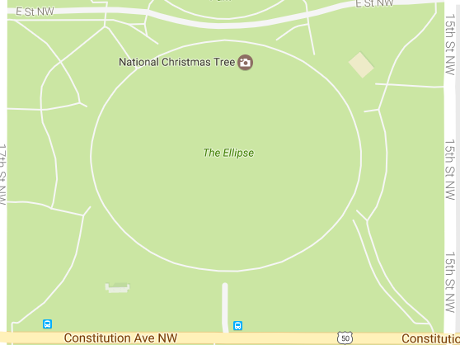
Plans for the Ellipse?


Purpose of Activity: In connection with the Presidential Inaugural Ceremonies, this application is for use of the Ellipse by PIC, in the event that PIC seeks its use for Inaugural ceremonies and any necessary staging, which is expected to be:

A) In the event that PIC seeks the use of the Ellipse for pre- and/or post- Inaugural ceremonies, the area will be used for staging the event(s), staging of media to cover and/or broadcast the event, and if possible for ticketed and/or public viewing; and/or ­

B) In the event that PIC seeks the use of the Ellipse for the Inaugural ceremony and Inaugural parade staging, the area will be used to stage the various parade elements, for media to cover and/or broadcast the event, and if possible for ticketed and/or public viewing.

The PIC has no plans to use the Ellipse but has reserved it no doubt to deny its use to others.

Those two applications close three out of three protest sites in the White House area. The PIC went even further to reach out and close off other potential protest sites.

Other permits granted to the PIC include:

Misc. Areas – Application 16-0357

Ten (10) misc. areas identified by attached maps for PIC activities.

Arguably legitimate since the camp followers, sycophants and purveyors of “false news” need somewhere to be during the festivities.

National Mall -> Trump Mall – Application 17-0002

The National Mall will become Trump Mall for the following dates:

Set-up dates starting 01/6/2017 6:00 am ending 1/19/2017
Activity dates starting 1/20/2017 ending 1/20/2017
Break-down dates starting 1/21/2017 ending 1/30/2017 11:59 pm

Closes:


Plan for Proposed Activity: Consistent with NPS regulations at 36 CFR 7.96{g)(4)(iii)(C), this application seeks, in connection with the Presidential Inaugural Ceremonies, the area of the National Mall between 14th – 4th Streets, for the exclusive use of the Joint Task Force Headquarters (JTFHQ) on Inaugural Day for the assembly, staging, security and weather protection of the pre-Inaugural parade components and floats on Inaugural Day between 14th – 7th Streets. It also includes the placement of jumbotrons and sound towers by the Architect of the Capitol or the Joint Congressional Committee on Inaugural Ceremonies so that the Inaugural Ceremony may be observed by the Joint Congressional Committee’s ticketed standing room ticket holders between 4th – 3rd streets and the general public, which will be located on the National Mall between 7th – 4th Streets. Further, a 150-foot by 200-foot area on the National Mall just east of 7th Street, will be for the exclusive use of the Presidential Inaugural Committee for television and radio media broadcasts on Inaugural Day.

In the plans thus far, no mention of the main card or where the ring plus cage will be erected on Trump Mall. (that’s sarcasm, not “fake news”)

Most Other Places – Application 17-0003

If you read 36 CFR 7.96 carefully, you noticed there are places always prohibited to protesters:


(ii) Other park areas. Demonstrations and special events are not allowed in the following other park areas:

(A) The Washington Monument, which means the area enclosed within the inner circle that surrounds the Monument’s base, except for the official annual commemorative Washington birthday ceremony.

(B) The Lincoln Memorial, which means that portion of the park area which is on the same level or above the base of the large marble columns surrounding the structure, and the single series of marble stairs immediately adjacent to and below that level, except for the official annual commemorative Lincoln birthday ceremony.

(C) The Jefferson Memorial, which means the circular portion of the Jefferson Memorial enclosed by the outermost series of columns, and all portions on the same levels or above the base of these columns, except for the official annual commemorative Jefferson birthday ceremony.

(D) The Vietnam Veterans Memorial, except for official annual Memorial Day and Veterans Day commemorative ceremonies.

What about places just outside the already restricted areas?

Dates:

Set-up dates starting 01/6/2017 6:00 am ending 1/19/2017
Activity dates starting 1/20/2017 ending 1/20/2017
Break-down dates starting 1/21/2017 ending 2/10/2017 11:59 pm

Closes:


The Lincoln Memorial area, as more fully detailed as the park area bordered by 23rd Street, Daniel French Drive and Independence Avenue, Henry Bacon Drive and Constitution Avenue, Constitution Avenue between 15th & 23rd Streets, Constitution Gardens to include Area #5 outside of the Vietnam Veteran’s Memorial restricted area, the Lincoln Memorial outside of its restricted area, the Lincoln Memorial Plaza and Reflecting Pool Area, JFK Hockey Field, park area west of Lincoln Memorial between French Drive, Henry Bacon Drive, Parking Lots A, Band C, East and West Potomac Park, Memorial Bridge, Memorial Circle and Memorial Drive, the World War II Memorial. The Washington Monument Grounds as more fully depicted as the park area bounded by 14th & 15th Streets and Madison Drive and Independence Avenue.

Not to use but to prevent its use by others:


Purpose of Activity: In connection with the Presidential Inaugural Ceremonies, this application is for use of the Lincoln Memorial areas and Washington Monument grounds by PIC, in the event that PIC seeks its use for the Inaugural related ceremonies and any necessary staging, which is expected to be:

A) In the event that PIC seeks the use of the Lincoln Memorial areas for a pre-and/or post Inaugural ceremonies, the area will be used for staging the event(s), staging of media to cover and/or broadcast the event, and for ticketed and/or public viewing.

B) In the event that PIC seeks to use the Washington Monument grounds for a public overflow area to view the Inaugural ceremony and/ or parade, the area will be used for the public who will observe the activities through prepositioned jumbotrons and sound towers.

Next Steps

For your amusement, all five applications contain the following question answered No:

Do you have any reason to believe or any information indicating that any individual, group or organization might seek to disrupt the activity for which this application is submitted?

I would venture to say someone hasn’t been listening. 😉

Among the data science questions raised by this background information are:

  • How best to represent these no free speech and/or no free assembly zones on a map?
  • What data sets do you need to make protesters effective under these restrictions?
  • What questions would you ask of those data sets?
  • How to decide between viral/spontaneous action versus publicly known but lawful conduct, up until the point it becomes unlawful?

If you use any of this information, please credit Amber Jamieson, Jessica Glenza and the Partnership for Civil Justice Fund as the primary sources.

See further news from the Partnership for Civil Justice Fund at: Your Right of Resistance.

Tune in next Monday for: How To Brick A School Bus, Data Science Helps Park It.

PS: “The White House Sidewalk is the sidewalk between East and West Executive Avenues, on the south side Pennsylvania Avenue, N.W.” From OMB Control No. 1024-0021 – Application for a Permit to Conduct a Demonstration or Special Event in Park Areas and a Waiver of Numerical Limitations on Demonstrations for White House Sidewalk and/or Lafayette Park

« Newer Posts

Powered by WordPress