Restricted U.S. Army Geospatial Intelligence Handbook
From the webpage:
This training circular provides GEOINT guidance for commanders, staffs, trainers, engineers, and military intelligence personnel at all echelons. It forms the foundation for GEOINT doctrine development. It also serves as a reference for personnel who are developing doctrine; tactics, techniques, and procedures; materiel and force structure; and institutional and unit training for intelligence operations.
…
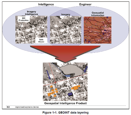
1-1. Geospatial intelligence is the exploitation and analysis of imagery and geospatial information to describe, assess, and visually depict physical features and geographically referenced activities on the Earth. Geospatial intelligence consists of imagery, imagery intelligence, and geospatial information (10 USC 467).
Note. TC 2-22.7 further implements that GEOINT consists of any one or any combination of the following components: imagery, IMINT, or GI&S.
1-2. Imagery is the likeness or presentation of any natural or manmade feature or related object or activity, and the positional data acquired at the same time the likeness or representation was acquired, including: products produced by space-based national intelligence reconnaissance systems; and likenesses and presentations produced by satellites, aircraft platforms, unmanned aircraft vehicles, or other similar means (except that such term does not include handheld or clandestine photography taken by or on behalf of human intelligence collection organizations) (10 USC 467).
1-3. Imagery intelligence is the technical, geographic, and intelligence information derived through the interpretation or analysis of imagery and collateral materials (10 USC 467).
1-4. Geospatial information and services refers to information that identifies the geographic location and characteristics of natural or constructed features and boundaries on the Earth, including: statistical data and information derived from, among other things, remote sensing, mapping, and surveying technologies; and mapping, charting, geodetic data, and related products (10 USC 467).
…
You may not have the large fixed-wing assets described in this handbook, the “value-added layers” are within your reach with open data.
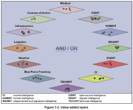
In localized environments, your value-added layers may be more current and useful than those produced on longer time scales.
Topic maps can support geospatial collations of information along side other views of the same data.
A great opportunity to understand how a modern military force understands and uses geospatial intelligence.
Not to mention testing your ability to recreate that geospatial intelligence without dedicated tools.